|
THE OCEANIC RIDGE BASALTS
Atlantic Ocean Ridges
(The
Geochemistry of Igneous Rocks - Geokem.com)
Caribbean Sea
Cayman Rise
This short spreading centre lies in the back-arc basin of the Lesser Antilles Arc.
 |
Cayman Rise.
Note the unusually high soda (4%), Ti and K. Though there is no useful trace data we can say they are moderate EMORBs with higher Na, K than is seen in the MAR but with 50-51% SiO2. |
The Atlantic Spreading Ridges
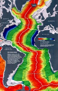
Map c/o Peter Sloss, NGDC, NOAA.
- click to enlarge (210Kb)
|
These basically form a single sinuous spreading rift zone, but offset
at intervals by transform faults, breaking it into sectors. It begins
at about 87 deg N in the Arctic Ocean and winds down parallel more or
less to the coasts of Europe, Africa and Americas to a point between
Cape Horn and the Cape of Good Hope, where it swings towards the Indian
Ocean.
In one of the classic stories of science, it was first conjectured by du Toit an hundred years ago that the Americas had separated from Europe-Africa because of the parallelism of the coasts and the matching of lithology.
Harold Hess in about 1954 proposed a mechanism of circulating subcrustal movement in the mantle by which this separation could be brought about, The proof was suggested by two Cambridge men, Vine and Mathews in 1963, who suggested that if the continents were separating along the mid-oceanic ridges, the rift between could only be filled by upwelling basalt. If this were so the flows on each side would be magnetised with paleomagnetic reversals matching on either side. A proton magnetometer trailed behind a military plane operating from Iceland soon proved the theory correct. Bill Bryson describes how a Canadian geologist Lawrence Morley had earlier pointed out the same thing but no-one would publish the paper. An editor of the J.G.R. told him, "While this may make interesting talk at cocktail parties, it has no place in a serious scientific journal!".
In 1964 I was introduced to an audience of about 1000 people in USA as "Coming from Australia where they believe continents float around like butter on a hot knife!" which was greeted by roars of laughter. I must admit I got a little sarcastic. Warren Carey of U. Tasmania. had long since convinced us all.
The main sectors of this ridge are:
(1) Nansen-Gakkel Ridge, Lat 87N.
This is formed from the most northerly volcanism known. Muhe et al, (1991, Tectonophysics 190, 95-108) indicates the presense of spinifex texture and komattites, but the samples analysed are not as magnesian as komatiites. Muhe later (1997) presented data which showed some of them to be close to E-type MORB with slightly elevated HFSE and slightly depressed LILE.
| [to come] |
The Nansen- Gakkel Ridge. |
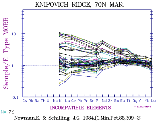
(2) Knipovich Ridge
This northern extension of the Mid-Atlantic ridge is of interest as
one would assume a very slow spreading rate. The Knipovich Ridge was
drilled as Leg-38, and two accounts by Rash & Eckerhardt,(1978,
In.Rep.DSDP, 38,719-730), and by Kharin, (Init. Rep. of DSDP 38, 685-715)
label samples as "altered". They certainly are! However more
recent data by Newman & Schilling, 1984 (C.Min.& Pet. 85, 209-22?)
show the rocks to be mainly E-type MORBs, with a few depleted samples
and a series trending towards alkali basalt. The data are limited to
those elements between Lu and K, presumably these authors were defeated
by the alteration, the LILE being particularly susseptible.
|
|
The Knipovich Ridge at 70ºdeg N |
 |
Variation diagram for the Arctic Ocean Knipovich Ridge. Somewhat altered and highly variable, EMORBS with 3.2% K2O have rather lower silica than usual at 47%. We have little data on fractionated high K EMORB and with alteration as an additional factor, cannot comment. |
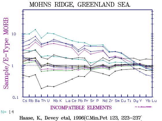
(3) Mohn's Ridge
|
|
This also lies in the Greenland Sea and also shows a range of composition centered about E-type and extending towards OIB. (Haase & Devey, 1996, C.Min.Pet. 123, 223-237) Several lineages are present as always seems to be the case in the more enriched areas.
|
 |
Variation diagram for the Mohn's Ridge, NE of Greenland. A wide range of EMORB is present giving an apparent scatter of data points. |
 |
The alkaline earth elements. Because the more enriched members are EMORBs, not higher fractionates, we get many reversals of relative abundance of elements. In the more depleted members the order is Sr > Ba > Zr > Y > Rb > Nb
In the EMORBs this becomes Ba > Sr > Zr > Nb > Rb > Y |
(4) Jan Mayen Platform
This segment is formed of alkali basalt-basanite-ankaramite-phonolite, culminating in Beerenberg volcano on Jan Mayen Island.
This is described under "Islands and OIB's of the Atlantic"
 |
Jan Mayen Island, with the currently dormant Beerenberg. Note the potassic composition of the trachytes and the pronounced increase in CaO in the ankaramite cumulates to the right. |
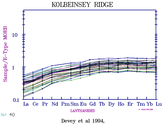
(5) Kolbeinsey Ridge
A great deal of new data has now (Mar., 2003) been added to the original data of Devey and Haase, (1994). PETDB now lists a dozen more publications and a total of 599 analysed samples. Unfortunately they have been analysed more or less at random and few are complete, many are done for a handful of trace elements and or isotopes without any ME data so we do not know with what rocks we are dealing. A few alkaline rocks, probably EMORBs are included but without complete data they cannot be defined with any certainty. Only whole rocks have been determined for REE, (except some glasses for La,Sm) and as Nb especially is very erratic for the WR samples but much better for glasses, it throws doubt on the many elements done on the WR samples.
A large number of Rb have been deternined to a high standard of precision
but not done for the ME, so we cannot give, eg, K/Rb., K/Ba, K/Cs or
K/Th figures, for some of the most depleted MORB rocks known (but similar
to the southern part of the Reykjanes Ridge to the south of Iceland.).
In fact precision is wasted on a single element.
Three or four of the WR have MgO greater than the 9.3% of the glasses and may be cumulates but this could be due to sampling. In general the very depleted nature of Kolbeinsey Ridge is supported, they show a single fractionated series except for a handful of more alkaline rocks of unknown parentage. However in the variation diagram FeOT shows a wide spread as if several lineages are present. Unfortunately, the presentation of iron ranges from (a) Total iron shown as Fe2O3T, (b) Total iron shown as FeOT, (c) Total iron (presumably) shown as Fe2O3; (d) Total iron apparently shown as FeO, and (e) Fe2O3 and FeO shown separately but in some cases with the ferric iron being determined on whole rocks and FeO on glasses of the same sample number.
It will be seen that the possibility of errors is high.
In general the Kolbeinsey rocks still appear to be among the most LILE depleted known, but similar rocks are seen in Reykjanes Ridge south of Iceland and in the EPR - Galapagos Rise. eg, we see that Ce and Nd have the same range, the ratio Ce/Nd being 1 . La/Lu is 4.6 .
Zr/Nb at 32 is subject to rather large uncertainty due to low concentration levels even in the glasses, and compares with 29 to about 80 for the EPR. Isotopic leads cluster near 18 for Pb 206/204 and 37.6 for 208/204, overlapping with the most depleted Icelandic rocks as well as EPR.
CaO and Al2O3 decline steadily with MgO from about 9.4% MgO showing that both plagioclase, olivine and pyroxene are forming together at this high MgO level. This compares with Hawaii where the same minerals do not appear until 7.5% MgO.
| |
Kolbeinsey is an extension of the Icelandic East
Rift Zone but north of an offset to the west along the Torjornes
FZ. One of the most depleted N-MORBS known. |
 |
Rare Earths shown against ppm La. The high Nd relative
to Ce is only seen in the most depleted NMORBS. Three of the high
La, Ce, Nd samples are more alkaline, possibly EMORB but data is
incomplete. |
 |
Variation diagrams for Kolbeinsey Ridge depleted
glasses.
Note 8 EMORB samples of higher Al2O3 etc. |
(6) Iceland
Though the MAR passes through the centre of Iceland being offset by
a series of transform faults on the way, its rocks are similar to the
ridge rocks, but with different distribution of fractionation products
with greatly more ferro-basalt, icelandite and rhyolite. The Theistareykyir
picrites in the north are depleted moderate NMORBs, as is Kistufel farther
south, while the several caldera-bearing shields superimposed on the
rift zones are highly fractionated moderate EMORBS, eg, the younger
Krafla, Askja, Torfajokull, etc. It now appears that the higher proportion
of higher fractionates are due to the locally thick crust, in turn probably
due to the multiplicity of fissure zones and the transcurrent displacments.
 |
Over 3000 Icelandic basalts-rhyolites with some alkaline rocks, GEOROC compilation.
These are "Whole rocks"; not glasses. We can see the cumulates
are all of olivine heading towards picrite and peridotites, mainly
from Theistareykir in the northern NVZ, a few from Reykjanes Peninsula,
Kistufel etc. Note also the low number of very low degree partial
melts resulting in smaller range of Fe, Al etc . Note also the very
prominent peaks in Ti and Fe at the TiMt IN point showing they are
almost all fractionated series, The low Zr/Nb and high La/Lu found
in low degree melt derivatives are absent except in the more alkaline
Hekla-Katla region.
The high percentage of fractionated rocks may simply be due to the greater crustal thickness allowing to formation of sub-crustal magma chambers where magma bodies may sit and fractionate for a few thousand years. |
The geochemistry of Iceland is described in detail under Atlantic Island OIB's.
(7) Reykjanes Ridge
This extends from the southern end of Iceland's west Rift Zone south into the Atlantic for some 200 miles. No complete data seems to be available (as at 1999).
Data from the Smithsonian Deep Sea Glass file (Melson & O'Hearn) show a steady increase in alkalis/silica over the last 60-80 miles rising quite steeply as the coast of Iceland is approached along with the alkali-basalt centres of southern Iceland. Schilling (1975,JGR 80) showed a similar increase in La/Sm over the same distance and Hanan et al(2000, G-Cubed) show Nb/Zr to increase in the same way. All these suggested a progressive increase in alkalinity rather than a sharp transition but more recent work shows that there are more EMORBs closer to Iceland, (see below). The REE of Schilling (1975) have in fact the same slope as those of the Kolbeinsey Ridge, (Devey et al, 1994) but lack the more depleted members. Total alkalies which average only 2% for Kobeinsey are only slightly greater (~2.2% average) for Reykjanes).
 |
Multielement variation diagram for FeO, CaO, Al2O3, Na2O, TiO2 and K2O for Reykjanes Ridge, Lat 52 - 64N. In spite of change in trace composition, the major elements are quite constant with mainly only Fe-Mg fractionation with a slight increase in K, Na. |
 |
Variation diagram for Reykjanes Ridge, N. Atlantic.
Reykjanes data including that of Murton et al (2000) Note spread of data with addition of more EMORB. |
 |
The REE of the Reykjanes Ridge.
Note overlap of Nd, Ce in NMORB, and the many EMORB done for La, Sm, Eu, Tb but not for Ce, Nd. At least 4 levels of decreasing Nd relative to Ce are seen in different EMORBs. (see also Zr, Nb below.) |
 |
Zr/Nb. Showing the plane of parental magmas from Macquarie Id, and adding fractionation paths demonstrates that at least half the enrichment seen in the "EMORBs" is due to fractionation. As all these rocks have virtually identical silica, the MAR does not become more "alkaline" towards Iceland as once thought. There do seem to be a greater number of lower degree melts occurring in superimposed seamounts but this could be accident of sampling. |
 |
Zr/Alk.Earths. Note large step in Ba between NMORB and lower degree-melt EMORB. Zr/Nb is more variable than it appears at this scale, (see below) and the Y, Ba, Sr become quite erratic in the EMORB. |
 |
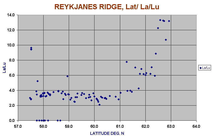
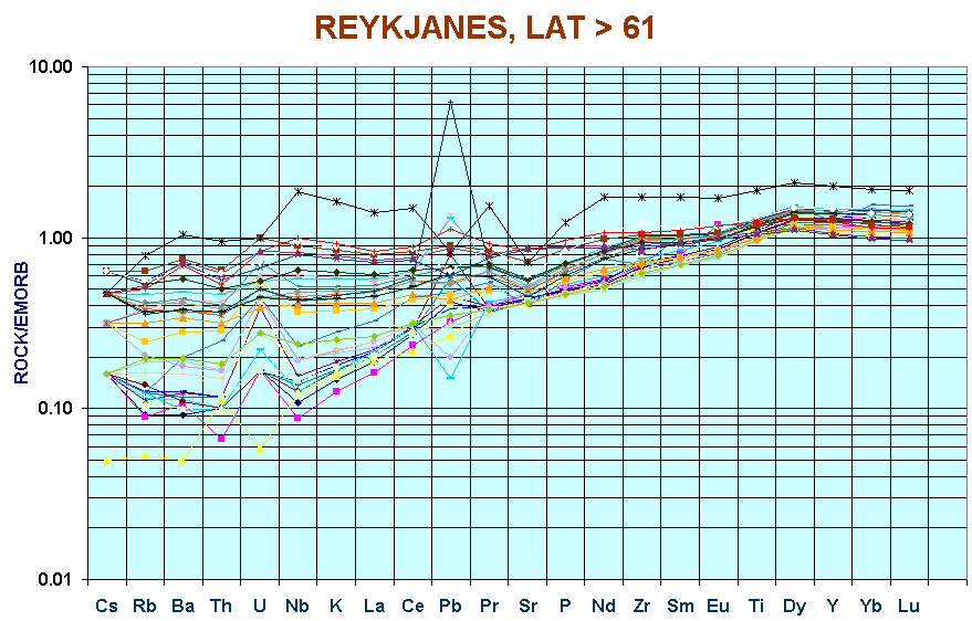
La/Lu shown for the Reykjanes Ridge. Unusually low levels south of 61N except for an occasional EMORB, possibly from seamounts. La/Lu along with Nb/Zr, La/Sm, K/SiO2 and Rb levels all increase north of Lat 61. |
>61ºN

<61ºN

|
The latest detailed work on the Reykjanes Ridge between Lat 57.5S and 63N with over 180 sites sampled by the RRS "Charles Darwin" has provided a great deal of new detail but raise even more questions. (Bramley. Murton et al, 2002, J.Pet.43, (11), 1987-2002). Perhaps the most surprising discovery is that the greater part of the ridge from Lat 61 south, though only spreading at 2 cm/year, has the most depleted NMORBS known though a handful of EMORBS also occur in the south. In general however the southern sector mainly is formed of NMORBS which have few rivals in the EPR, Galapagos Rise, in the rest of the MAR or IOR. Ba is very low at only 5 -17ppm, only about half the level of Y which is unusual. La/Lu at 2 - 4 and La/Sm of ~0.75 with Nd/Ce > 1 are all parameters rarely seen. |
 |
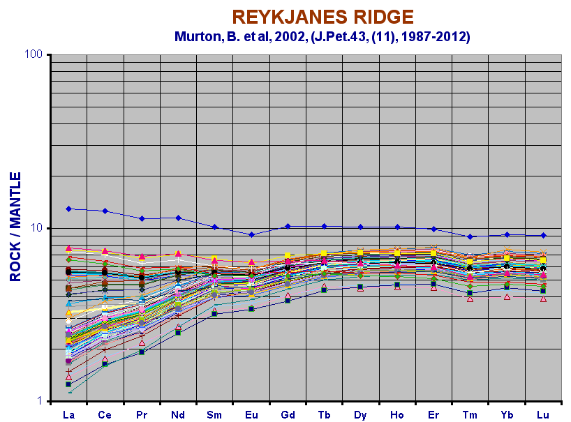
Rare earth elements. Reykjanes Ridge.
(Murton, B., et al, 2002, J.Pet.(43), (11), 1987-2002). |
 |
Ce/La for Reykjanes Ridge. The more depleted NMORBs with Ce/La = ~ 3 have a lower La relative to Ce compared with the EMORBs with ~ 2.5. |
(8) Gibb Fracture Zone
 |
This is the separator between the Reykjanes Ridge stemming from Iceland, and the MAR at 52 deg N lat. Not as one might imagine, a higher degree melt zone. A small range of composition but with a few peridotites present. |
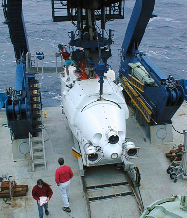 The submersible "Alvin"
ready to be launched from the research vessel "Atlantis"
|
|
(9) The Mid-Atlantic Ridge
 |
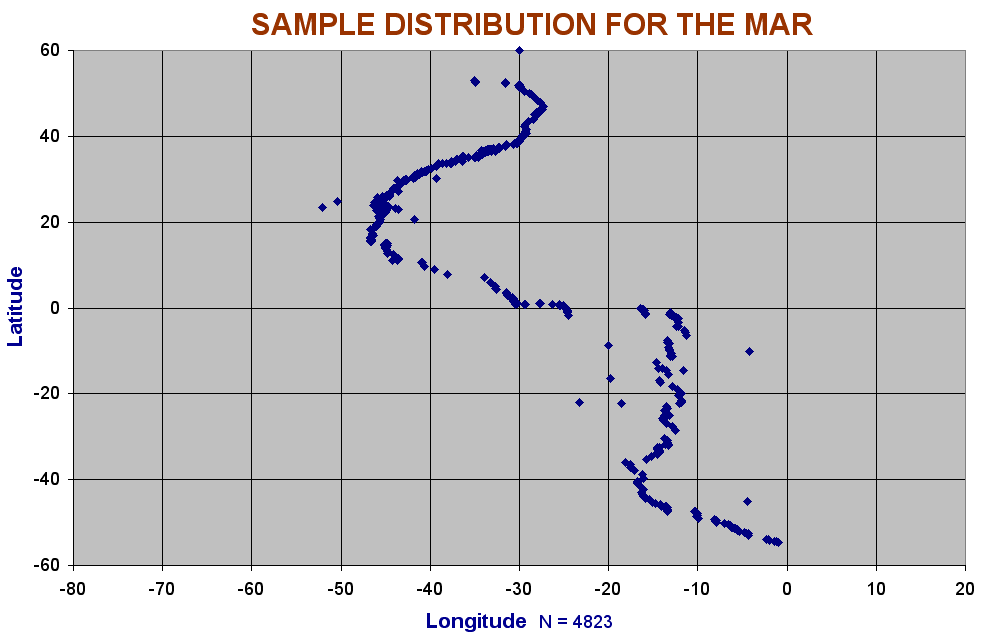
Latitude vs Longitude distribution of samples collected.
The sampling has been quite dense but almost entirley restricted
to the youngest, active ridge. |
 |
Variation diagrams for 3089 glasses of the MAR between Lat 55S and 52N, i.e.south of the beginning of the Reykjanes Ridge.
Note small degree of fractionation compared to the Galapagos Rise, but a wider range of partial melts so different sectors with different melt percentages result in a wide variations over the whole ridge, e.g. at 8% MgO iron varies by 4%. The flattish base to the iron trend where the partial melt plane occurs is rather ragged in this case, reasons unknown. |
 |
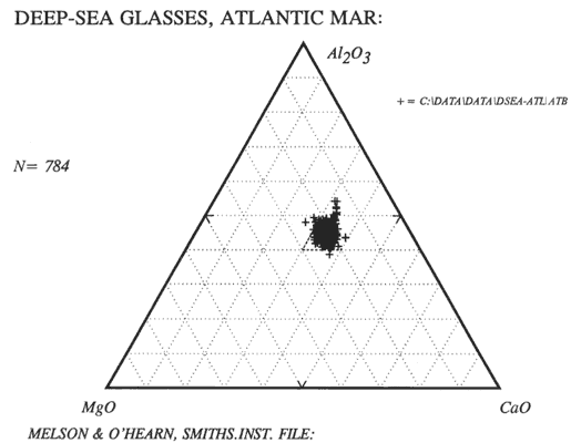
Ternary Al-Mg-Ca diagram for 784 Atlantic Ridge basaltic glasses. A small number of plag basalts are present, but they are otherwise restricted to the "Basalt Triangle".
Being aphyric glasses there are no crystal cumulates,
gabbros or picrites present, but basalts enriched in Fe or Ti (sometimes
called Fetibasalts) and ferrobasalts are included. c.f. same diagram
in "Summary" for crystalline and altered basalts. |
 |
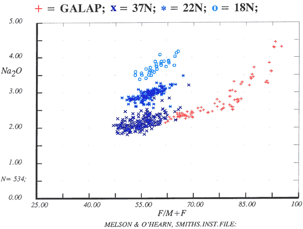
Variation in soda for 18N, 22N, 37N North Atlantic,
MAR. The smaller degree-melt EMORBS have the highest soda (and LILE
ingeneral)
Note the more basic members of the Galapagos Rise ferrobasalt-dacite
group have a similar soda level to that found at 37N, being both
depleted NMORB. |
 |
La/Sm for the MAR. The blue line shows the plane of
parental melts from Macquarie Id. As both olivine and plag plot
near zero, all fraction trends for the NMORBS at least, trend away
from that point in en eschelon fashion. Note that fraction of all
MORB is limited in the Atlantic though the La/Sm may be = or <
1 through to > 4. Except in Iceland, no "Icelandites"
or commendites are present. |
 |
La/Sm variation with latitude for the MAR. High values
are associated with local, possibly quite accidental sampling of
EMORB seamounts. Sampling is very poor, whole sections of as much
as 2000 nm of ridge have no TE or REE data whatever. Even then,
the same samples may not be done for ME, REE and Isotopes. Much
early work done in the Atlantic was before the days of ICPMS and
before the importance of using glasses was realised. |
 |
Plotting K/Ti against latitude shows locations of the
many drill sites (as many more samples have been analysed for the
ME), but K/Ti is an unreliable indicator of enrichment due to changing
fractionation paths. Because the minimal parental magmas do not
have less than 0.5% TiO2, this has been subtracted. |
 |
Glasses MgO vs K2O
A wide range in parental magma is seen but limited fractionation
effects. |
|
Leg-37
|
|
|
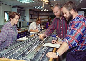
Core logging aboard drillship (photo: ODP)
|
In 1970 it was suggested that Canada have the use of the "Glomar
Challenger" drill ship for a season. I agreed on condition
we tried for a "Deep Hole" now that techniques had improved
since the days of the failed "Mohole" project. However
there was an outcry when is was found that this high prestige
project was to go to Canada and as a compromise the core was split
in half and other "investigators" shared the other.
In May the following year, there was a special AGU meeting where
the results were to be presented. The JOIDES committee described
the site location, Fab the core handling, sample preparation,
heat flow etc, and I presented the chemistry including the famous
Mg/Y diagram. Not a single other "contributor" had completed
their work. Granted we had the only computer controlled XRF in
the world at the time, but it did demonstrate that for many people
the grant is the focus of interest, not the results!
Our attempt at a deep drill hole resulted in four being drilled
on the site to about 400m and gave us a more varied range of rocks
type than was found before or since, but techniques were still
not so good in 1972. Some REE have been done but are so impossibly
unusual, eg with Nd double the Ce, that I do not believe them
for a moment. Some Zr/Nb also show a wide scatter with values
that again look highly suspicious, so the total results for so
much work were not that great. It might be worth while to look
at just how much work was undertaken for Leg-37.
Historical Note
In the late 1960's Fab Aumento of Dalhousie
U had been concentrating on an area at 45ºN and sending me
some of the samples to analyse, and the various flows in that
area were well mapped. However the JOIDES Committee did not agree
with the sample site as a possible deep-drill site, it was too
far north they claimed and they demanded it be shifted to south
of the Azores, an area neither we nor anyone else knew a thing
about. Fab had discovered that an Oceanographic ship costs almost
as much sitting alongside in Bedford Basin as it did at sea, so
he had no compunction about dialling Ottawa and demanding a ship.
"We sail Friday at 6pm, can you
be there?" So telling the students
to look after themselves for a few weeks, I caught a late flight,
Fab met me at the airport and an hour later we steamed out of
Halifax in the icebreaker "Hudson". We crossed the Grand
Banks in thick fog (as always), the wretched fathometers seemed
to delight in locking onto side echoes and had to be continually
manually monitored.
A job pushed onto me was carrying out four hourly pollution trawls, the amount of tar lumps to be got was truly amazing. I had warned the Newfie crew not to throw anything over the side during trawl periods but one day a young Newf seaman boy came cheerfully whistling up the rail and slung the ships garbage over the side. I let out a roar a rage and took after him, aiming a kick at every second step, he fled like a deer leaping over winches and cables, dodging like a maniac. The Newfie crew all gathered about cheering loudly, a frequent threat to be heard was "I’ll kick your arse all over the deck!" and they were delighted to see an old custom put into practice.
My victim finally dropped into some bolt-hole where I could not follow and I had to give up. However there were females on board, a practice new to me, and they complained loudly about my brutal behaviour, but the Newfs said, "Lard Jasus bye, he’ll be thinkin’ twice the next toime!"
There were many other adventures, too many
to tell here. One involved the near loss of the "Hudson"
as Sherry Goodrich, the only female officer in the Canadian Navy
at the time, took over the watch as we approached Antigua on a
dark night, with the radar out. The previous watch keeper was
an elderly skipper of a war time cargo ship and had been on the
beach for some years. He should have stayed there! I was on the
bridge doing some star nav at the chart table.
Having been to Antigua before by
yacht, Sherry realised we were far too close in shore, did a quick
check taking bearings on a cape and the dimly-seen loom of the
Airfield beacon hidden by a hill, said something unprintable and
ordered "Hard over starboard!"
and gave her full ahead port, full astern starboard and full bow
thruster.
"Aye, Mate!"
said the helmsman and spun the wheel. I watched the fathometer
as it crept down to below 23 ft,
"What does she draw, Mate?"
I asked and she replied, "Twenty
one!" but after hovering at
22ft it slowly it crept back! I walked out to the wing of the
bridge, even in the dark, a flood of mud and stirred up bottom
debris could be seen astern. Watch over, Sherry came to my cabin,
"For God’s sake gimme a drink!"
she said, "I bloody need it! We
must have been within 6 inches of going on the bricks! I might
have ripped the rudder out of her! Mind if I cry on your shoulder
for a bit?".
"Aw, come off it, Mate!" I
said, a little alarmed. "A miss
is as good as a mile any day, at most you pruned off a few barnacles.
Bet you get another half knot out of her!'
Sherry glared at me over her rum. "Nice
to know I've shipped along of somebody a girl can always turn
to for a bit o' comfort. Tell me, are they all like you in your
country?
"Nah!" I said,
"They're mostly a bit rough round the edges, You might say
you got the pick o' the bunch!"
"God help me!" she said.
"I'll have another rum!"
On site onthe MAR we lowered three radar transponders on anchors and steamed back and forth, back and forth mapping the bottom. Recording was rather primitive, the radar scope readings had to be continuously recorded by hand onto a chart. We picked sediment ponds for the drill holes to be spudded in, hauled up (and later analysed) basalt pillows in a chain grab, and measured heat flow. We finished the cruise by steaming down to Antigua.
The following year four holes, 332A, 332B, 333A, 333B and 334 were drilled. We encountered pillow basalts, EMORBS, gabbros, troctolites etc, a wider range that had been ever penetrated before.
|
 |
Variation diagram from our data only. A group of ordinary tholeiites is seen, and a plagioclase-rich group which sends of a line of sample to high Al anorthosites, and another limb towards picrites. The low CaO group also has a picrite (high MgO) trend. On the far right are olivine gabbros and at 20% MgO, eucrites. The anorthosites send a tail of low FeO towards zero. |
 |
Variation diagram from all data from 5 contributors.
The interlaboratory agreement is not good. Surprisingly Leg 37 is
one of the few sites where picrites and anorthosite cumulates have
been found. |
 |
Metals for Leg-37. Cr reaches as high as 4-5000 ppm and Ni to 2000 ppm in the High Mg gabbros of Site 334, not often seen in ORB rocks. |
 |
The famous Yttrium/MgO diagram.
I believe this was the first time Y was ever analysed by XRF or done at all accurately. A tail extends towards picrites and towards anorthosite at zero. The gabbros and eucrites were not done which is a pity, but we rather looked on this as an experiment. |
|
|
As well as our own and the shipboard analyses at least three other centres duplicated our work as did the U.S.G.S. The analytical agreement was not good, so that when all data is combined the fine detail is obscured.
No prize for guessing whose data we preferred!
- "FAMOUS" Area.
- Kane Fracture Zone
(10) The South Atlantic part of the MAR.
 |
The dozen lowest MgO points appear to have high
K. These prove to be from the region close to Bouvet Island and
are alkaline extending the trend in the Ti/Mg diagram somewhat.
The rest range from 0 deg lat to 55 S2 and in spite of the "Dupal
Anomaly", show little variation. Data from Smithsonian Deep
Sea Glass File.
Note: data from Romanche Fracture Zone and from 40 - 52.5S not included |
(11) Romanche Fracture Zone
This lies exactly on the equator and is a major dislocation along a transcurrent fault of the MAR, as one might expect as it lies opposite Fernando de Noronha and the major offset shown by the coast of northern Brazil extending to Cabo San Roque, and the major inset of the African coast from Liberia to the Gulf of Guinea.
Samples collected from this sector of the MAR by the Russian oceanographic
ship "Ackademician Strakhov" during cruises 13 and 16 have
recently been described by V.Kamenetsky, R.Maas, A.Sobolev, N.Sushchevskaya,
S.Eggins, and S.Skolotnev; "Unique Glasses and Melt Inclusions
from the Equatorial Atlantic: A new "Hotspot" in a cold Suboceanic
Mantle." Poster presented at the EGS-AGU-EUG Joint Assembly, 2003,
Nice.
Glasses dredged from this sector have unusually variable and wide-ranging
compositions and include some of the most extremely enriched EMORBs
to be yet described from the MAR. Averaging 4% soda at 6% MgO they are
also among the most sodic EMORBs found.
 |
Romanche FZ EMORB diagram,
for 91 Romanche FZ glasses. Compare with diagrams for the 40-50.2S
region and for the EPR. also Macquarie Id. |
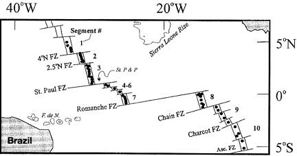
Chart of the Romanche FZ sector,
Kamenetsky et al, 2003 |
 |
MgO vs Oxides for Rom. FZ. |
 |
K vs Cl, S. As seen in Macquarie, Cl increase rapidly
with lessening degree of melt, as well as with fractionation. |
 |
|
The Romanche samples are close to the composition of the primary melt series found on the defunct spreading centre of Macquarie Island, (Kamenetsky, et al., 2000, J.Pet. 41; Kamenetsky and Maas, 2002, J.Pet. 43) south-west of New Zealand, along with some slightly fractionated members. Some parameters coincide exactly with Macquarie, but some other element ratios show distinct differences, eg K/Rb = 332 cf 260.
 |
Even though the primary magma line of Macquaries
points very close to zero, some variation in fractionation result
is possible. Th/U = 3 as opposed to an average of 3.5 in the parental
magmas. Does this affect the Pb 206/208?
In the Galapagos Rise we see Th/U of only 2.5. K/Nb shows an even
greater divergence between Macquarie and the Romanche zone. |
Major difference from Macquarie appears to reside in the more variable
HFSE. The most enriched members however differ in being of low silica
and plot in the basanite field of an alkali/silica diagram, a feature
not often seen elsewhere, extreme EMORBs usually plotting in the hawaiite,
and even tephrite fields.
Even more remarkable is the extreme variability found in single dredge
hauls, eg in Cruise 13, Dredge 12, glasses range from 0.11% K2O to 1.86%
were found, also with Nb 2.7 – 78.2, La 4.4 to 53.3 ppm.
More will added to this preliminary account of these remarkable rocks
when full publication has been released.
Both the Romanche Fracture Zone and Macquarie Island are largely
EMORB primary melts with very minor fractionation in some members.
The paths for both partial melt and for fraction are almost parallel
as may be seen when compared to the fractionated EPR basalts. How
then does this marked difference occur? The most likely explanation
is that very minor differences in K and Rb in the mantle, sets the
paths of partial melting off in different directions. So when comparing
a K/Rb ratio (or any other) we must be careful to stipulate whether
we are debating a fractionation trend or a partial melt trend. All
MORB series recovered include some primitive and unfractionated members.
Only occasionally are these of a wide spread in composition with only
a minority of fracationated members. Were the two trends to diverge
widely, a broad cluster of points would be seen.
(12) The Speiss Seamount Ridge
Here, near 70S, the seamounts analysed by Dima Kamenetsky, have very high K, Ba and low Nb, U, Th, Rb as for the South Atlantic in general. Some samples have inexplicably high P as well.
 |
Speiss Seamount. EMORB Diagram |
 |
Speiss Ridge. EMORB Diagram |
(13) The South Atlantic Ridge from
40 – 52.5 deg S
This sector extends almost to the triple point junction with the SWIOR
and the Antarctic – South American Ridge. Petrus le Roux et al
(2002, EPSL 203, 479-498) have described in some detail the compositions
of some 150 samples dredged from this sector. They range from common
NMORB, to potassic EMORBS, being one of the more mixed parentages known.
The authors ascribed this to a complex origin, intimating that some
are part of the "Tristan-Gough Plume", some belong to a group
opposite the Discovery seamount which they ascribe to the "Discovery
Plume", and in the extreme south, to the "Shona Plume".
To explain the high K content of the region they suggest that the local
sub-lithosphere mantle was enriched by subduction of oceanic crust from
the Andean Trench to the west and underthrust to the Mid Atlantic Ridge.
However, it is difficult to agree with this as , while high K and Ba
seem give a negative Nb, the rocks have none of the characteristics
of calc-alkaline andesites having no positive Pb, Th, U, Rb, while Nb
is quite compatible with other elements except for the K.
Neither do any of them have the characteristics of the highly alkaline
Tristan – Gough rocks which have up to 7% K2O (cf 1.2% max) and
5% TiO2 with a much lower silca down to 43% cf 50-51%. The SAT rocks
follow typical EMORB compositions, eg, in their K2O / Silica, and lie
well within the bounds defined in "ORBs, Summary" for EMORB.
 |
Multi-element diagram normalised to EMORB, showing
wide parental range. Note general high K and Ba relative to Nb |
 |
REE Normalised to EMORB for 40-52.5 S. |
 |
La/REE showing tendency for only slight fractionation
in clumps of sample of differing La/Sm. |
 |
Zr diagram showing derivation from many paranetal
magmas, the more EMORB with very high Sr. Compare with Galapagos
Rise. |
 |
Mg/K showing variability. |
 |
The range in La/Sm from <1 to ~ > 4 |
 |
Variation diagram showing limited fractionation. |
 |
LILE element distribution for the most enriched EMORBs
of the South Atlantic at 1.2% K2O, 7% MgO approx. Ba and K appear
to dominate in the EMORBs but in Sth Atlantic NMORB, Rb, Ba, Th,
U, Nb, Pb remain "normal" while the K is much elevated.
Zr/Nb = 8. This appears to be true for the area between Tristan
and the Atlantic-American Triple point junction. (37 - 52S)
Regrettably good TE data for the South Atlantic is very limited,
eg we have none for the apparently sodic region near St Helena. |
(13) American Antarctic Ridge
 |
This spreading centre lies E-W at 55 S at the southern end of the MAR. A few High K samples are present but when located these are all from the close proximity of the alkaline Bouvet Island. The erratic Ti's may be data errors. |
 |
Variation diagram (MgO vs Oxides) |
HOME
Copyright © 1998-2006 Dr B.M.Gunn
|