Atlantic Ocean Volcanism,
OIBs, Tholeiites and Basanites
(Ocean Island Basalts)
|
(1) Iceland 
|
Iceland is a large mid-North Atlantic island, built entirely of basalts and fractionated derivatives. It is located right on the Mid-Atlantic ridge spreading centre but is the locus of more than it's share of volcanism, hence is called a 'Hot-Spot'. In the literature frequent reference is made to "The Icelandic Plume".,
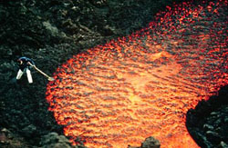 A recent flow from Hekla
Photo: Thor Thordarson
|
However, the Icelandic rocks are no different to any other ridge sector world wide except for the appearance of more than the usual number of fractionated members. Accordingly, Iceland perhaps should not be grouped with "Oceanic Islands" but instead with "Oceanic Ridge Basalts".
As shown in the map below, the eastern and western parts of the island are old basalts of Tertiary age becoming progressively younger inwards to the active spreading axis, or 'Neo Volcanic Zone'. Instead of being linear, the spreading axis has split into a reversed "h".
The northern submarine Kolbeinsey Ridge is offset by the Tjornes Fracture zone from the East Rift Zone of Iceland. Frequent rift effusions of lava take place from fissures along the rift zone, but in places is focussed on central volcanoes which form low shields, such as Krafla and Askja in the northern half of the ERZ which include not only basalts and ferro-basalts but also more silicic rocks including icelandites (or low-Al andesine bearing andesite), rhyodacite and high Nb-Ta 'rhyolites' with albitic feldspar and quartz, unusual in the oceanic environment and elsewhere seldom found except found in the Galapagos Rise and the EPR.
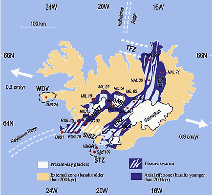
(from Chauvel & Hemond, 2000)
Southwest of the Vatnajokull Ice Sheet, near a smaller one called the Torfajokull is the well known Hekla volcano, and under the Vatnajokull itself, is Bardabunga and Grimsvotn which have been erupting recently. South of Hekla between Vatnajokull and the smaller Myrdallsjokull are the two well known rift zones of Laki and Eldgja which lie parallel. In 1783 Laki poured out 226 sq miles of lava from a 15 miles long rift which flowed a distance of ~40 miles. The heavy gases, SO2, H2S and Cl2 hung over the island killing half the live stock and consequently nearly 10,000 people died of famine. It is ironic that given some wind, they might have lived.
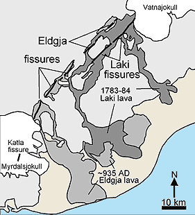 Thordarson, T., Miller, D.J., Larsen, G.,
Self, S. and Sigurdsson, H., 2001.
J.V.G.R. 108, 33-54
|
The Eldgja Rift, in 935 AD erupted some 19.6 cubic miles of lava from a rift 30 km long, the eruption lasting 3-8 years. Because of the longer time period, the effects were not so drastic.
Hekla and the Katla centre which lies under the Myrdalsjokull near the south coast are both somewhat more alkaline than the basalts of the northern part of the ERZ having about 1% more alkalies at the same or lower silica level.What about Laki and Eldgja which lie between? There is some major element data and some partial trace element data by Wood, (1979) and by Meyer, (1985) from which appears that Laki-Eldgja do not have a transitional composition like Hekla-Katla and belong to the low-alkali tholeiite suite. However, even for Hekla while we have good major element data (see below) there are only two more or less complete analyses by Hemond et al (1993). According to Tronnes (pers comm), the Laki fissure is a southern extention of the Bardabunga-Grimsvotn centres under the Vatnajokul and these erupted ash at the time of the Laki eruption. Similarly, Eldgja is an extention of Katla to the south. However, Eldgja appears to be of the low-alkali group.
|
Out to sea along the southern continuation of the ERZ lie the active Westmanneyjar Islands which are ankaramites-hawaiites and mugearites but there is no further activity south of these islands.
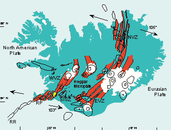
Einarsson and Saemundsson. 1992
|
For the Mid-Iceland Belt joining the ERZ to the West Rift Zone there are only sporadic data available. Another small ice sheet, the Hofsjokull lies in the middle of this zone. The Hofsjokull and Kerlingarfjoll volcanic systems occur here but while there are post-glacial lavas, none are historic. Data of Meyer (1985) from Sprengisandur in the MIB show the rocks to be low alkali, low Ti, basalts
The West Rift Zone includes the Langsjokull area and the Hengill centre south-west of Reykjavik which (according to Tronnes (1990)) has erupted 25-30 km 3 of hyaloclastites and lava in the last 0.11Myr, mainly in the post-glacial era. The WRZ then extends down the Reykjanes Peninsula including Skalafell and the Grindavik areas to the offshore Reykjanes Ridge which links to the Mid Atlantic Ridge. In 900 AD the large Hallmundahraun flow was formed from craters on the NW of the Langsjokull, and in 1000 AD the Svinahraun erupted from SW of Hengill, not far from Reykjavik. Basalts from Thingvellir, north of Reykjavik include two ferro-basalts with up 4% TiO2, (Meyer 1985).
West again, on the Snaefelsnes Peninsula is a small area of alkaline volcanism, more alkaline than the Westamanneyjar. A single flow has erupted here in historic time.
Iceland has it's own characteristics, though similar in general to other basaltic islands. Moderately depleted olivine basalts with low LILE are common, being similar to N-type MORBs. Hawaii is dominated by occasional picrites, plentiful enriched basalts and FeTi basalts with ferrobasalt. Iceland has depleted high-Mg basalts with up to 21% MgO, but these are usually coarsely crystalline. Few have a clear-cut picrite trends as seen in Hawaii, they seem rather to be accidental olivine phenocrysts accumulations. Rocks called 'picrites' occur in the northern ERZ at Theistareykjir and in the WVZ at Hengill and the Reykjanes Peninsula.
The Theistareykjir High-Mg rocks have a very regular Mg/Ni trend yet when MgO is plotted against CaO only about 5 lie on a 'picrite trend'. Ca and Ni are both lower than in Kilauea or Mauna Kea, while MgO/Cr and MgO/Co are both erratic indicating the involvement of clinopyroxene.
|
|
MgO/Ni for Theistareykjir, (Slater et al, 2001) compared with Kilauea, (Gunn, 1967) and Mauna Kea, (Yang et al, 1996). |
|
|
Variation diagram for all Icelandic rocks, (N = 3722). These range from depleted high degree melt olivine basalts and picrites to the right, to rhyolites and more alkaline to transtional rocks, (Hekla-Katla) tp the left. The Westmaneyjar and Snaefellsnes alkaline rocks are excluded.
Note wide range in K especially. Rocks with high alumina (20 - 30% are mainly xenoliths from gabbroic intrusions, eg the Krisuvik gabbro in the Reykjanes Peninsula.
Note distinctive ferro-basalts with high TiO2 (5%) |
 |
Icelandic Basalt-Rhyolites. Ternary FMA diagram. The Icelandic rhyolites are seen lower right. The picrites appear to converge on an olivine of very constant composition as in Hawaii. |
 |
Na2O-MgO-K2O for Iceland. More potassic than depleted NMORBs but similar to Hawaii and to EMORBs and most OIBs. The many scattered points seem to belong to hydrothermally altered Tertiary basalts such as the Austerhorn complex. ORB's by contract have more DMORB fractionates and less EMORB fractionates. Thus may be due to thick crust in Iceland compared to the thin Oceanic crust. |
 |
Vanadium shows a strong peak coinciding with Fe and Ti at the TiMt point. Co is almost unaffected by the Theistoreykjir picrites which so strongly influence the Ni, (and Cr). |
 |
All Icelandic Basalts - MgO vs Alkaline metals |
 |
Variation diagram for all Icelandic basalts MgO showing the Ti (In) point (Compare with V above) and the P (in) point where titanomagnetite and apatite appear on the solidus) |
 |
Variation diagram for all Icelandic basalts MgO vs metals. |
 |
Th vs U |
Ferro-basalts are common both in the Neo-volcanic zones and in the older Tertiary lavas with iron peaking at about 16-17% , but Ti is erratic, peaking at 4.5% in Hekla-Katla, (Sigmarsson et al, 1992) but at only 2.5% in Krafla, (Nicholson, 1991).
Icelandites and high Nb rhyolites (known in the Galapagos and in the EPR but not in Hawaii) are fairly common in the shield volcano centres. Rhyolites often occur as composite dikes, ie, as a basalt dike with a rhyolitic core, (Gunn & Watkins, 1969). I do not know of any composite dikes occurring outside of Iceland. It appears that a basalt rising through an old fractionation chamber, brings trapped rhyolite to the surface.
In 1970 we did multiple analyses of a single 11m thick basalt flow from the East Iceland Tertiary, and found it quite variable due to variations in plagioclase-cpx-op, while late stage puddling of residual liquid gave small pockets of sanidine--quartz which greatly increased the local Rb, Cs content so that K/Rb ranged from 640-1600, (Watkins, Gunn & Coy-Yll, 1970). Whether this happens in rocks in the Neo-Volcanic zone we do not know though a variation of about 10% in most elements was found in a very LILE-depleted flow from Theistareykjr (McLennan et al, 2003, JGR B 108). However when data are accumulated from the Tertiary rocks from both Eastern Iceland and from the Skagi Zone to the west, (Carmichael, 1964; Wood, 1977; Gunn & Siggurdsson, 1970, unpub.) as well as from the Neo-Volcanic Zone (Hemond, et al (1993, 2000); Meyer, 1985) and from centres such as Krafla, (Nicholson etal, 1991; Nicholson & Latin, 1992; Jonasson, 1994) and many others; it seems there are few differences between any of the Icelandic rocks, ie the La/Sm (average, 2), the Zr/Nb (average 10-12), Ce/La, Ba/Rb etc tend to stay the much the same except in the most alkaline rocks of the Snaefellsnes area. Fingerprints appear to differ in slope between depleted rocks and rhyolites, due to partial fractionation involving clinopyroxene, as dacite - rhyolites have higher La/Sm ( 4 -6) and lower Zr/Nb ( 3 - 6) than olivine basalts but the overall pattern remains the same.
In spite of the many depleted primary melt rocks and the erratic Fe/Ti in the ferro-basalts (as seen in all ORB rocks), the Icelandic tholeiitic rocks are fairly consistent in their trace element relationships, such as Ce/La, Zr/Nb, Ba/Rb, K/Rb and La/Sm, the range of moderate NMORB to moderate EMORB being less than seen in world wide ridge systems, but with similar means. The slow spreading rate of about 2 cm per year accounts for the absence of extreme NMORBS though these are found in the oceanic ridges to the north and south.
 |
A more or less random selection of recent Icelandic rift zone lavas shows a range from NMORB to somewhat fractionated EMORB. These are whole rocks, not glasses but show a similar dispersion to those seen in Oceanic ridges though rather more erratically. A similar distribution was shown by Kempton etal, (2000, EPSL 157, 255) |
 |
The Austurhorn complex is outside the Neo-volcanic zone and rocks are somewhat altered, but it is evident that the this series is formed from EMORB and fractionates (shown by falling Ti and P) of up to commendite. |
Icelandic Magma Types
Sited as it is astride the Mid Atlantic Ridge, Iceland might be expected to be formed of the same type of rock as the ridges to the north and south, possibly becoming somewhat alkaline in off ridge areas as all oceanic islands do with time as their magma source tends towards an origin deeper in the crust.
At first sight, Iceland is an oddity with the appearance of common "andesitic" (andesine basalts or "Icelandites") first described by Ian Carmichael (1964), from the Eastern Tertiary lavas of Thingmuli and the common occurrence of high Nb rhyolite, which is seen in the EPR - Galapagos Rise, but seldom elsewhere. Unlike the submarine ORBs, the rocks have been extensively fractionated, which may be simply due to the greater local thickness of the lithosphere, caused by the close association of no less than nine en echelon rift zones up to 10 km or more wide and active transform faults, producing an unusual level of lava emission. There is therefore room for subcrustal magma chambers to form in which fractionation may take place.
Magma types to be found in Iceland range as we now know, from a moderate olivine-fractionated NMORB as seen in the Theistoreykjir lava field at the northern end of the East Rift, in Kistufell somewhat to the south and in random flows associated with other centres such as Herdubreid, Krafla, Hengill and the Reykjanes Peninsular. With LILE enrichment these vary continuously through the moderate EMORBS which make up the bulk of the island, to the transitional lavas found at Hekla-Katla to the ankaramite – alkali basalt – hawaiites found on the Westmann Islands at Helgafell and the Surtsey Islands and also on a failed ridge sector in the west at Snaefellsness. Actually we do not know the ratio of EMORB / NMORB as fractionated "central volcano" types as seen in Krafla have been more often studied than the monotonous NMORB olivine basalts.
Unlike the abrupt cessation of tholeiites as seen in the older Hawaiian shields when giving way to superficial alkaline post shield AOB- hawaiite-mugearite-trachyte, in Iceland the NMORB - AOB is continuous and gradational. Fractionated moderate EMORBs not only appear form the bulk of the present island, but appear to in the older Tertiary rocks as well, in fact I do not believe any NMORBs have been discovered in the Tertiary series. However, preferential selection of sample has been at work, rhyolite for example is less common than the number analysed would suggest,
EMORBS have somewhat lower silica, of about 47-48% as opposed to 49 -51% seen in the NMORBs. The bulk of Icelandic lavas are the same though some may be a percent lower, but almost all samples analysed have been WR’s, not glasses and there is little we can be precise about
As in all ORB rocks, Sr is fractionated out to low levels in the more depleted members due to plagioclase, but in the more enriched members this doe not occur and Sr may be > Zr.
Fractionation Trends
While some centres of glacial age include chilled glasses and pillow lavas ( Kistufell and Herdubreid), most analysed samples are whole rocks, and separating cumulates from high magnesian magmas is not always possible. There appear to be three main fractionation trends.
Olivine fractionation is seen in rocks of > 10% MgO. Some may be mere olivine cumulates but others, eg ithe more basic of Theistoreykjir lavas have lower La/Sm to <1 and Zr/Nb = 17 (McLennan etal, 2003, EPSL 194, 67-82) etc and may be primary magmas.
Plagioclase plus olivine fractionation is the most common as in all Oceanic Ridges. It is indicated very clearly by Sr/Zr in most centres, where because of the Sr entering plagioclase, the Sr level may remain constant or even decrease with increasing Zr, Y, Nb, Ba, La etc as is seen in EPR rocks especially. Samples with Zr < 100ppm may trend towards olivine and may be liquids or cumulates. In the Helgafell – Surtsey alkaline rocks, this flattening of the Sr trend does not take place until about 200 ppm Zr is reached with Sr ~ 400 ppm.
Whn clinopyroxene appears the mineral proportions are usually in the ratio of 12% ol - 33% cpx - 55% plag and the residual liquid move downwards towards rhyolite. The point at which Cpx appears cannot be fixed as yet.
 |
CaO vs MgO for all Icelandic tholeiites. At first sight this simple diagram is at variance with the statements above, where plag + ol and Plag + Cpx + Ol fractionation is mentioned. However it is obvious with a little reflection that both Olivine and Plagioclase must lie on the prolongation of the main olivine trend, A mixture of 60% plag and 40% Ol would lie on the trend shown. Similarly a cumulate of 12% Ol + 33% Cpx and 55% Plag lies on the upwards prolongation of the basalt - rhyolite trend. Ti-Mt removal des not affect a Ca/Mg trend. In the absence of glasses, the finer points cannot be distinguished. |
 |
MgO vs FeOT for Icelandic tholeiites. Here we see iron at about 8 - 9% pointing towards olivine on the right. These may be liquids or cumulates. At 10% MgO with the incoming of plagioclase. there is a sharp change in direction. Fe/Mg does not change appreciably with cpx and the trend continues until the TiMt point is reached where ferrobasalts suddenly precipitate their Fe, Ti, V (and incidentally greatly increasing silica.) |
 |
CaO vs FeOT for Icelandic tholeiites. Perhaps surprisingly the change from Ol + Plag to Cpx + Plag does not make a great deal of difference. |
The best fractionated series is that of Hekla but basic members are missing and there are no rocks with > 8% MgO. The relationship between time between eruptions and silica content shows fractionation is continually taking place. Here the cumulate is mainly cpx+plag, but what earlier cumulates are we do not know, a good drill core is needed. Strong curves in, eg Ba,Sr/MgO show that it is not simply a basalt-rhyolite mixing series as has been claimed.
Ankaramite ( ol + cpx) fractionation is well seen in the alkaline rocks of Helgafell, Surtsey etc in the Westmann Islands and Sr resumes its steep climb with fractionation as seen in the picrite series, as Cpx contains little Sr and Ol none.
The increase in LILE elements from NMORB to alkali olivine basalts appears to be quite regular and the decline in silica may be due to no more than the displacement by the extra LILE. Transition from Ol, Ol + plag fractionation to Ol + Cpx seems to marks the boundary from tholeiite to alkali basalt.
With the advantage of hindsight it is obvious that fractionated EMORBs so rarely seen in thin Oceanic crust, might well be found in local areas of thicker crust such as Iceland, and we were all very stupid not to realize the possibility. Many published papers refer to Iceland having enriched mantle, metasomatised mantle, lithospheric contamination, underlying continental crust, plume contamination etc etc none of which are involved in the formation of ORB series so it is unlikely they are involved in Iceland. McLennan et al, (2001) term the Herdubreid sequence "Plume Driven". We can only comment that if so, then so is every ten-mile sector of the whole world-wide ridge system as such rocks are very common.
NMORBs of Iceland
Theistoreykyir
This lava field occurs at the northern end of the East Rift zone, and consists mainly of moderate NMORBS and picrites of 5 – 24% MgO. At more than 9-10% MgO, all trends are towards pure olivine, and Sr remains always at a higher level than Zr, though as most of the rocks are WR’s and not glasses, the inevitable scatter is present. The La/Sm is as low as 0.5 and the Zr/Nb as high as 40-50 in the most magnesian rocks suggesting they may be non-cumulates. More fractionated rocks have La/Sm of about 1.5 and Zr/Nb of 20 – 8.
 |
Variation diagram for Theistoreykjir. This appears to be mainly subject to ol control. |
 |
Zr vs Alkaline Earth elements for Theistoreykjir. Sr shows olivine trend only except perhaps at the uppermost levels. This order of Sr > Zr > Ba > Y > Nb > Rb is almost the same as seen in chondritic meteorites, though in the latter Rb is closer to Rb = Nb, Rb being later concentrated in the Earth’s crust. |
 |
REE of Theistareykjir normalised to EMORB showing moderate NMORB pattern. |
 |
Multiple analyses of a single lava from Theistoreykjir, also showing a moderate NMORB normalised REE pattern. (McLennan et al, 2003, JGR (1), ) The paper is not immediately available, but we can assume the samples were whole rocks. |
Kistufell
Kistufell is a 4755ft table mountain lying immediately north of Vatnajokull consisting mainly of moderate NMORBs; K. Breddam (J.Pet. 43, 345-373, 2002) finds olivines as magnesian as Fo 89.7 and claims an origin in depleted mantle. As may be seen in the chapter on ORB studies, NMORBs are high degree melts and accordingly low in LILE elements, and there is no need to postulate mantle variations to explain their origin.
 |
Variation diagram for Kistufell. CaO especially shows a kink at 10% MgO, where rocks more magnesian trend towards olivine. |
 |
Zr vs Alk. Earths. Some samples of < 10% MgO and > 120 ppm Zr have Sr no longer parallel to the other LILE due to incoming of plagioclase. |
 |
REE diagram normalized to EMORB for the moderate NMORbs of Kistufell. |
 |
This EMORB normalised diagrams shows that Kistufell is a moderate NMORB. Some alteration effects are seen in Cs and Pb. |
Herdubreid
This centre forms a steep-sided complex formed by chilled basalts intruded into the Pleistocene icesheet so pillow lavas and glasses are present. A small subaerial cinder cone occurs at the summit. New data are mainly from McLennan etal, (2001, EPSL 194, 67 - 82)
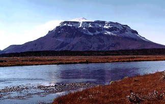 |
Mt Herdubreid
The effects of confinement on a subglacial lava eruption are well shown. Marginal chilling against melt water results in these unusually steep-sided cones. One might expect the outer walls to be formed of pillow basalt.
Note the cinder cone on the summit.
|
 |
Variation Diagram for Herdubreid, with 6 – 12% MgO |
 |
La vs REE for Herdubreid showing even distribution at typical EMORB levels. However the more magnesian samples are NMORB. |
 |
REE of Herubreid normalized to EMORB showing EMORB pattern |
 |
Zr vs Zr, Nb, Y, Sr, Rb, Ba for Herdubreid. The Sr distribution begins to flatten at the highest levels. |
 |
Zr vs Nb for Herdubreid. The plane of possible parental magmas from Macquarie is shown. Two samples appear to lie on the cumulative side of the plane. Kamenetsky (2000) analysed two more high Mg lavas from Macquarie but at 36.78 Zr and 1.35 Nb they do not depart from the line shown. |
Hengill
Hengill is a mountain lying a few miles south of Reykjavik on the Reykjanes Peninsular. The name also seems to be applied to the general district of several subparallel fissure zones lying along the West Rift zone, Since Pleistocene glaciation times, thick layers of faulted pyroclastics and flows have been built up. There also several geothermal areas.
 |
Variation diagram for the Hengill region including picrites. This diagram is quite important. Note the sharp angle at about 9% MgO. At high MgO levels we have first picrites, then ol + plag troctolites, which are joined at 9% MgO by clinopyroxene. This is exactly the same as seen in Oceanic basalts (see ORB chapter) and confirms the fractionation trends for magnesian ORBs. It is a pity these rocks are not glasses, but the fractionation path seems to be quite distinct. Data mainly from Reidar Tronnes, (1990) |
EMORB central volcanoes
Krafla
Krafla forms a low 25 km-wide shield astride a fissure zone 80km long and 4 – 10 km wide in the northern sector of the ERZ and has a central caldera. A magma chamber has been detected 5 – 8 km below the surface. There have been 18 eruptions in the post glacial era, the latest in 1984. Nicholson and Latin (1992) found some NMORbs to be present.
 |
Krafla variation diagram from 5 – 11% MgO. |
 |
OIB-type rhyolite of Krafla, coupled with similar rhyolites from the Archaean of Kidd Creek, Ontario. Note the only slightly -ve Nb-Ta, and high HFSE compared to Calc-alkaline or Arc rhyolites which may be an indication of an origin by separation of late stage felsic liquid from trapped sub-lithosphere or intra-crustal basalt..
Note also great similarity between samples with an age difference of 2.7 ga. |
 |
REE diagram normalized to EMORB showing wide spread of composition from NMORB to fractionated EMORB rhyolite. |
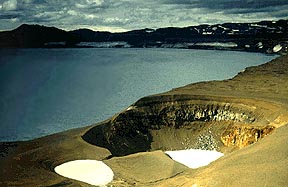 Askja is a low shield in the East Rift Zone, on the northern side of the Vatnajokull, with a large lake-filled caldera. Viti crater in foreground, (Photo: C. Wageman)
|
Askja
This is rather similar to Krafla with a low shield with multiple calderas astride a 100 km active fissure zone. The youngest caldera is occupied by a 500ft deep lake.
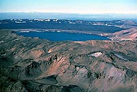 Aerial photo of Askja with crater lake. Rhyolitic ash appears below younger basalts. The main caldera eruption took place in 1875 with 8 more minor eruptions in the 20th century. The older caldera wall is seen in distance along with in-filling basalts. (Photo: Michael Ryan, USGS)
|
 |
Askja variation diagram with basalts to rhyolites, but with more magnesian members missing. |
 |
Zr vs AE for Askja. Note the flattened Sr trend. |
 |
Normalised REE diagram for Askja.
Fractionated EMORBs but missing basic members. Some missing values, eg for Pr have been interpolated. |
 |
La/Sm for Askja. The non-constant ratio suggests that some of the basic members may be primary magmas,
but inclusion of cpx in the fractionating lavas might have the same effect. |
 |
Askja rhyolites showing in this case, some Nb depletion in the rhyolites. |
Tertiary Lavas of East Iceland
The data of D. Wood, (1978, J.Pet.19, 395-436)) may be old but has always been regarded as being of good quality. The Thingmuli data of Carmichael (1964, J.Pet.5) has similar ME but TE were not included. These show similar moderate EMORBs with La/Sm = ~ 2, and Zr/Nb averaging 9.
 |
EMORB normalised digram for the Tertiary basalts of Eastern Iceland.
Again we see fractionated EMORBS extnding into rhyolite (commendite). This could suggest that the present slow spreading rate at Iceland of ~ 2 cm a year, has been similar since Tertiary times. Dy was interpolated. |
 |
Variation diagram for E. Icelandic Tertiary. |
 |
K/MgO. The use of WR’s has resulted in scatter, so that precise fractionation paths cannot be arrived at. |
 |
REE normalized to EMORB for E. Icelandic Tertiary. |
 |
La vs Sm. Again the ratio changes continuously. I do not think we can be dogmatic as to whether this is a primary feature or due to the cpx in fractiontion cumulates. |
 |
Zr vs Alkaline Elements |
 |
La vs REE |
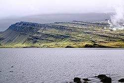 |
Gently westward dipping flows of Tertiary age, Hamarsfjordur Eastern Iceland. South of Berufjordur and the village Djupivogur. (approx 64°40' N & 14°30' W)
Photo: Kristjan Jonasson, Icelandic Institute of Natural History, Reykjavik.
The peak on the left is 460m. Lava flow thickness is from perhaps 5 to 30m. The dip is to the west. This is a general feature of Icelandic geology that the basalt layers dip towards the rift zones. They are around 8 - 9 M years old.
|
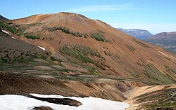 |
<< The Gyltar rhyolite dome in the Western tertiary lavas.
Photo: Kristjan Jonasson, Icelandic Institute of Natural History, Reykjavik.
As you can see in the photo there are not many exposures to look at and no good contacts. It is extrusive and a bit elongated in form. A caldera is not directly observable, but circumstantial evidence indicates that there probably was a caldera. There are a couple of rhyolites there and they occur at the edge of the inferred caldera. It seems to be quite common in Icelandic central volcanoes to have rhyolitic domes close to caldera rims.
|
Transitional Magmas
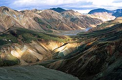 Torfajokull
Photo: Kristjan Jonasson
Click to enlarge.
|
Torfajokull
This is a EMORB-commendite complex lyiing about 10 km W of the Myrdalsjokull and the Laki - Eldja zones.
The greater part of the complex, (see pic>>) is of sub-glacial rhyolitic tuff with some rhyolite and obsidian but a complete range from basalt is present. The main part of the complex if > 10,000 yr old. Dark rocks on far right distance overlying pyroclastics are massive commendites. Mineralogically these rocks contain oligoclase, anorthoclase, augite, mt, il, hbnde (edenite to ferro-edentite), fayalite + ap, zr, pyrr. (Jonasson, pers.comm.; Gunnarson , 1998, J.Vol.Geothem. Res, 83, 1-45)
Though commonly referred to as "rhyolites", these rocks have little in common with continental rhyolites, though similar to the nearby Hekla rocks. They appear to be classical fractionated EMORBs with 10 - 11% alkalis at 70 - 73% silica. Nb is very high to nearly 250 ppm with an average Zr/Nb of 5.5 (see below). None of these parameters are seen in continental rhyolite. Zr reaches 2200 ppm whereas it is seldom higher than 3-400 ppm in continental rhyolite. K20 is high rising to about 5% from a low 0.2% in the basalts. The distribution is mainly linear which might tempt the proponents of "magma mixing". Mixing of basalt and rhyolite can occur in Iceland as we once showed in our " Composite Dyke" (Gunn & Watkins, 1969, G.C.A. 33) but the sudden decline in Sr at about 300 ppm Zr as well as the decline in Ba and even Rb in the commendites show the effects to be more likely due to fractionation. Mork, (1984, Lithos 17) also McGarvie etal, 1990, J.Pet.31, 461-484) have suggested hybridisation and indeed some may occur but the strong curves in Al2O3 seen in the comendites, and a lesser degree in CaO and FeO do not agree with magma mixing though the Ti and Fe distribution is variable and not distinct as it is usually. In a basalt-commendite complex some hybridisation is almost inevitable.
In general the same trends are seen in the more basaltic Krafla and Askja complexes.
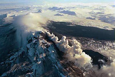
Mt Hekla in recent eruption, view north along the rift.
Note the two fresh black lava flows to the right. Elongate mountain ridges in distance are apparently due to subglacial lava emerging along rifts in the Pleistocene glacial time and being confined by ice and prevented from spreading laterally.
Photo: Thor Thordarson, Volcanic Institute of Iceland, 16-Feb-1991 |
Hekla-Katla-Grimsvotn
|
|
Ternary diagram for Hekla.
+ = data from Sigmarsson et al (1992);
* = data from Gudmundarsson (1992);
x = data from Hemond et al (1994).
Hekla is slightly more alkaline than the usual East Rift Zone rocks having on average about 1% more alkalies. However, though transitional none of them are alkaline even the periperal centres. Hekla is an elongate dome aligned along a rift on the western side of the ERZ. and throughout historic time has erupted on average about once per 100 years. However lately it has speeded up with eruptions in 1970, 1980, 1991 and on 26-Feb-2000. Eruptions begin with rhyolitic components, reverting to basalt, and it is claimed that the longer the period between eruptions, the more felsic the early magmas are.
The Hekla rocks form a remarkably linear line of liquid descent. Unlike Krafla there is no sign of parallel, multiple magmas of different parentage. As the best example of a fractionated series is worthy of much more detailed study.
The whole series are highly Nb enriched with "rhyolites" with >80ppm. |
 |
Th/U for the Hekla basalt - rhyolite fractionated series. Th/U is 3.2 in basalts but increases slightly to 3.6 in the rhyolitic members. |
 |
Mg Variation diagram for Hekla, note the high TiO2 peaking at 5% at 5.5% MgO as does FeOT at 16%, ie ferro-basalts. P2O5 peaks at about 3.3 % MgO. |
 |
In spite of the small amount of data for an interesting centre with the longest known history in the Western world, there is enough Sr and Ba data to show the regular upturn for Ba and decline in Sr for the low Mg members. |
 |
The K/SiO2 diagram show a curve similar to fractionated EMORBs, but a group of about 46% SiO2 are included, too low for ORB basalts. It seems Hekla may have begun as an EMORB off-ridge centre but has become mildly alkaline. It share some similarities with the offshore Helgafell series. |
| |__| |
Variation diagram for Hekla – Katla |
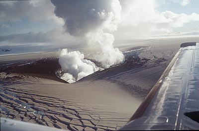
The Gjalp vent 1998, ERZ, which occurs in a chain including Grimsvotn and Bardabunga centres. The ice of the Vatnajokull can be see fracturing as it flows inwards towards the melt zone round the vent. The ice is covered in a layer of ash.
Photo: Scientific Inst., Uni. of Iceland |
Alkaline Magma Zones
Westmann Islands, Heimaey, Eldfell, Surtsey etc.
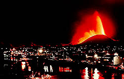 The Vestmannaeyjar Islands The Vestmannaeyjar Islands
This small group of islands off the south coast of Iceland were called after a fisherman named Westmann, who first saw the smoke and steam rising out of the sea. The main vent of the biggest island of Heimaey is Helgafell. I seem to remember another called Kirkufell because it was near a church, but that may have been an early name for the 1967 vent named Eldfell. In about 5 months over 400 houses were destroyed; Heimaey being the main fishing port for Iceland. Though most of people were evacuated, the Icelandic fire brigade made a truly heroic defense, pumping millions of gallons of seawater onto the advancing lava to form a barrier wall of chilled lava. They did not play around with garden hoses as people on Hawaii have been guilty of doing with the Pu'u O'o flow. Flows advancing up streets were stopped, and later bulldozed away, saving much of the town, the port being actually enlarged. Helgafell and Eldfell are a mildly alkaline basalt, hawaiite mugearite. Other recently emergent islands to the south, Surtsey, which emerged in 1963, Syrtlinga etc are, according to the data of Tania Furman et al, (1991), more mafic ankaramites, but these follow the same geochemical trends. Compared to the tholeiites of the NVZ, the Vestmannaeyjar rocks are defined by their steep increase in soda plus a lesser amount of K at constant silica. Their P2O5 is also almost double that of the mainland rocks. In spite of this most other element pairs such as Ce/La, La/Sm, Th/U, Zr/Nb are similar, even the K/Rb is the same at 400. The Hekla-Katla series have different trends, being intermediate between the Vestmannaeyjar and the Neo-Volcanic Zone series as regards their soda, P etc.
 |
Repeated seismic activity in Reyjkavik emanating from the Hengill centre immediately south of the city has alarmed residents. Hengill of course is in the West Rift zone, only a few miles away. At a meeting in Auckland on geothermal activity, an Icelandic geologist made rude remarks about people that build cities on top of volcanic fields!! (such as Auckland)
We are told that now even the family pets in Reyjkavik are on active volcano watch. |
 |
Westmanneyjar Islands - Zr vs Alkaline Elements |
 |
Variation diagram for the Westmanneyjar ankaramite-alkali basalt-mugearite series.
Note that the Na/K ratio is very high, but decreaces from 6 - 4.4 with fractionation. This compares with Na/K of 1 for Gough, Heard Id etc. (Furman et al, 1991) |
 |
Metals for Helgafell-Surtsey. V has a flat distribution in the ankaramites (on right) quite different to ORB rocks, while Ni does not climb so steeply with MgO. Co and Sc are similar ot ORB while Zn is elevated toward the mugearite end on left. |
 |
MgO/Alk-Earths
We still have a distinct Y>Nb>Rb as in ORBS but the differences are much less.
In more alkaline rocks this becomes Nb>Rb>Y. Note how regular the Ba, Zr, Sr are compared to the erratic NMORB - EMORB. However, unlike the more depleted NMORB, Ba is present at much higher levels than Y. |
 |
Zr/Hf is rather high at an average of 43.3. Note the origin is at about 0.5Hf which may explain the increasing Zr/Hf in alkaline rocks. |
 |
REE for Helgafell etc. Note that Pr as well as Dy, Ho, Er and Tm have been interpolated as EXCEL does not like zero values in log plots. The lower group are the ankaramites from Surtsey etc. |
 |
Helgafell-Surtsey REE diagram normalised to EMORB (~= average oceanic crust). |
|
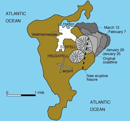
Heimaey (USGS Map)
|
 |
Eldfell and Helgafell. |
 |
Alkali basalts to Ankaramites from Surtsey and Surtlinga islands south of Heimaey, (1963) |
 |
Snaefellsnes Alkali basalts. |
 |
Snaefellsnes trachytes, |
 |
Snaefellsnes Alkali Basalts, from the extreme SW of Iceland.
(REE diagram) |
The Snaefellsnes alkali basalts lie in an isolated area on a peninsula NW of Reykjavic and are somewhat more alkaline than the Vestmanneyjar.
|__| Zr vs Nb, Y, Sr, Rb, Ba for Helgafell-Sursey. Note that with ankaramite fractionation, the steep increase in Sr is resumed
Jokulhlaups
These are glacier bursts occasioned by immense amounts of ice being melted by subglacial eruption. Eventually the water finds its way out a subglacial channel and for a few hours or days may pour out millions of cusecs, washing away any roads, bridges etc downstream.
Copyright © 1998-2006 Dr B.M.Gunn
BACK
|


