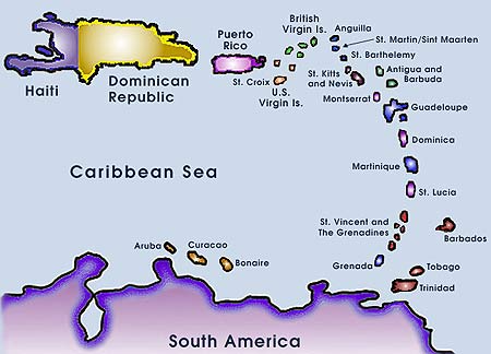
The Lesser Antilles Arc The Lesser Antilles are a chain of 15 major and many minor volcanic islands extending north and north-west of Trinidad and enclosing the Caribbean Sea. The arc is bordered to the north and west by the Puerto Rican Trench which reaches a depth of up to 9200m. Active strato-volcanoes are found in the submarine Kick 'em Jenny, north of Grenada; at Soufriere at the northern end of St Vincent; at the well-known Mt Pelee at the northern end of Martinique; at Soufriere on the island of BasseTerre, Guadaloupe; and at Montserrat. There is also the geothermal area at Soufriere, St. Lucia. Other islands, while not active in historic times cannot be considered extinct, including the islands of Saba at extreme north-western end of the active arc, St. Eustatius (or "Statia"); St Kitts, dominated by the Mt Misery centre, Nevis which has a single cone and crater also has some geothermal activity; and Dominica. Grenada alone which has reached the usually late stage of producing alkaline orogenic basalts is probably completely extinct. The Lesser Antilles constitute a sub-mature arc. No proto-arc members are present nor mature arc as seen in the Est Indies or Honshu arcs.
The outer splinter arc or "Limestone Caribbees" are islands of about Cretaceous age built of albitised and chloritised arc andesites, ie, spilites and keratophyres, while what appear to be spilitised MORB basalts (except for their low Ni) are found on la Desirade. Often these rocks are capped by uplifted limestone reef material, hence the name. This group include Marie Galante, Grand Terre, la Desirade, Antigua, Barbuda, Saint Barts, Sint Maarten, and Anguilla. We did quite a study on the spilites and keratophyres of Antigua especially but while we learnt a lot about altered volcanics, it did not tell us much about arc evolution. Historic Note. |__| A soda, MgO, K2O ternary diagram for the Lesser Antilles. These still have their uses, as the "Early Arc" nature of the Antilles is immediately seen. High soda rocks from Sint Eustatius, high K rocks from Granada, and high Mg from Aruba, Curacao. Field work on tropical Volcanoes We soon found in 1966 why little geological work had been done on some islands. Much of the slopes of Mont Pelee for example is covered in jungle in which lives the dreaded fer de lance snakes. We found an elderly black man who made a living collecting bounty on the fer de lance. He walked in front carrying a very sharp machete and had a quick eye and an even quicker hand. Fer de Lance have a reputation for psychological warfare, lying on a tree branch and letting four men of a passing party pass underneath and then dropping on the fifth. Fortunately our snakes seemed not to have attended this school of subversion. Dug-out canoes or pirogues allowed access to remote pieces of coast. Officials on some islands tried to prevent us taking out rock samples and we soon found that working from our own yacht was the only sensible method, the prices at tourist hotels also being horrendous. No one looked in the bilges for boxes of rock which could be claimed as "ballast". Islands of multiple centres such as Guadaloupe, are often mainly built of block and ash with little massive flow, and overlap in many directions. The explosive nuees ardentes of Pelee described so vividly by Lacroix and by Perret are in fact the norm in all eruptive centres of the Lesser Antilles. Just which centre a block may have originated in can be hard to impossible to judge. At least two of the samples we collected from what we thought was Morne Jacob on Martinique, have Pelean chemistry, (Gunn, Roobol & Smith, 1974, BGSA). Exposures of even recent eruptions can be quickly hidden by vegetation. Once we were taken by Seismic Institute up a creek to the west of Souffriere St Vincent, to view what had been determined was to be the type area for the 1903 eruption. While we were looking at the exposure, Alan Smith walked a few yards further up the creek and stopped and pointed with his hammer handle at a fresh face exposed by rockfall. Saba and Statia are controlled by Holland, and in an interview with the Governor we made the mistake of asking whether they had any contingency plans for evacuating the islands in case of eruptions. We were finally told that until such plans were formulated we could not mention in any publication that Saba and Statia were volcanic as "it would alarm the population". The penalty was that of not being allowed to set foot on the islands again! I don't believe our work on Statia, easily the most important done at that point in the whole of the Antilles, has been published to this day, but it has been included below. Geochemical summary:
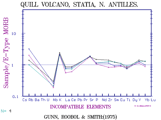
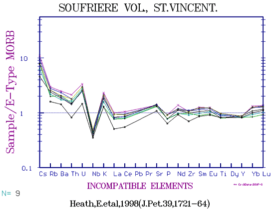
The geochemical trends for the orogenic andesite series confirmed those found earlier in Mexico and can be easily distinguished even in basalts from those of MORB, CFB or OIB origin. The range basalt-basaltic andesite-andesite-dacite-rhyolite may cover from 45 to 75% SiO2 and 10 - 0% MgO. Silica increases steadily throughout any series, as does K, Rb, Ba, Th, U, Ti, Zr, Y and as we later found, Cs, Nb and the light REE. Al2O3 remains more or less constant, and soda shows an increase but proportionately less than K. The other elements Mg, Cr, Ni, Co, Ca, Fe, Mn and Ti, all decrease, always being at a maximum in the basalts. There is no trend towards high Ti & V ferrobasalts as found in MORBS, OIBs, and CFB's and no reversals in slope. TiO2 does not exceed 1% in the Lesser Antilles and the Ni is remarkably low, usually less than 20 ppm. P reaches a maximum in basaltic andesites at about 3% MgO and then declines, the only element to increase from basalts and then decrease towards rhyolite. Sr stays roughly constant in all rocks at about 300 ppm levels but is much higher in the alkaline rocks of Grenada and lower in the "Early Arc" rocks, such as in Statia.. We had not then any capability for analysing the REE. Up until recently, we have had to make up fingerprint diagrams for the Antilles by including REE from partial data by Thirwall, et al, 1994, (J.Pet. 35, (3), 818-838) by matching rocks of similar TiO2. Davidson et al, (1986, JGR B91, 5943-62) have analysed samples from several islands including REE but without major elements except silica, and unfortunately without Nb or Ta which are essential for orogenic rock typing. Turner et al,(1996, EPSL 142,191-200) include Nb and Pb and Sr isotopes but in some instances have only 2-3 samples from an island we know to range from basalt to rhyolite. However, we can now show the approximate range of composition for the series as a whole, if not for the island components. The range is not great, though the fingerprints can show distinct differences. In 1975 we examined northern island of Statia and found not only a complete range from basaltic andesite to soda rhyolite but that all were soda enriched and very K depleted with a K(60) of 0.6 with most residual elements close to or below EMORB except for the relatively elevated Cs, Rb, Ba, K as in all Arc rocks. Saba only a few miles away has a K(60) of 1.2 cf Mont Pelee with 1.0. There is in fact little major element chemical difference between most of the islands of the Antilles, the apparent differences in fingerprint being enhanced by the fact that basalts from one centre or island are being compared with andesites from another and dacites from a third. Baker(1984, J.Geol. Soc. Lond. 141, 401-411) and Brown et al, (Geoch. Cos. Act. 41, 785-801) claim there is a progressive change along the arc with St Kitts (which is only slightly more potassic than Statia) being tholeiitic compared to the calc-alkaline southern islands as I once tended to think in 1975.
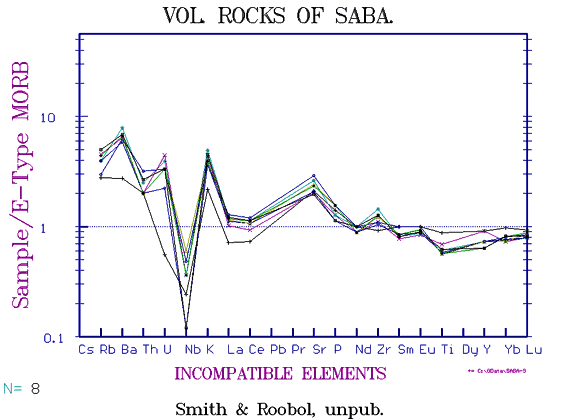
Compared to the variation seen in most other arcs, this is trivial yet as seen below, the fingerprints show quite a wide range in LILE content, in fact we showed in 1974, (Gunn, Roobol & Smith, GSAB 85) that in Martinique while Pelee had a Rb(60) of about 22, in Morne Jacob it was 60, in du Carbet 40 and in Pointe du Diamant about 18. It may be that the range in fingerprints for Martinique might be as great as in the whole arc as Statia has Rb(60) of 12 while St Kitts, Montserrat, and Basseterre (Guadaloup) average 18-20. Normally, a series of basalt to rhyolite, eg those of Puyehue, in Chile (Gerlach & Frey et al, 1988, J.Pet 29) have all members showing a parallel fingerprint pattern. Changes in slope in REE diagrams usually means a change from tholeiitic to alkaline, at least in MORBs and mature calc-alkaline series, but seemingly not here. In the Lesser Antilles a large increase in LILE elements and a decrease in HFSE does not correspond with an increase in soda relative to Si. So we must leave the puzzle unsolved for the present, and look for similarities in other arcs. In the Tonga-Kermadec arc, very depleted islands such as Niuatotatapu and Niuafou again have higher total alkalies than more evolved centres with enriched LILE such as Raoul and L'Esperance, due to higher soda, (Ewart & Collerson et al, 1998, J.Pet.39). In the Izu-Bonin Arc, Proto Arc compared to Active Arc rocks with higher LILE again show no difference in total alkali content (Pearce et al, 1999,J.Pet.40). Saba Saba is a high island in the extreme north-west of the arc and is rather odd in that in consists of a series of overlapping domes rather than pitons mainly ringed around a central depression in which lies a village called "Bottom" as opposed to a village on the rim called "Top" and another on the windward side of the island called "Windward Side". While there has been no activity in historic time, hot springs and a newish looking sulphur flow suggest it is only a matter of time! Some of the andesites are packed with amphibolite inclusions of MORB composition. While Saba has double the K of Statia (K(60) = 1.2, vs 0.6), the rocks are fairly close to Mont Pelee in general composition.
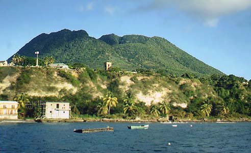
Statia has a single young cone at it's south-eastern end named The Quill, the crater floor being only a little above sea-level. At the western end are a series of eroded remnants of andesite cones of at least Pliocene age, the island being 9-10 km long. The cliffs below the main town of Orangestadt are layered light-coloured block and ash, including as we immediately guessed when we first saw them from the sea in 1976, dacites and rhyolites, this being only the third rhyolite exposure to be found in the entire Lesser Antilles.
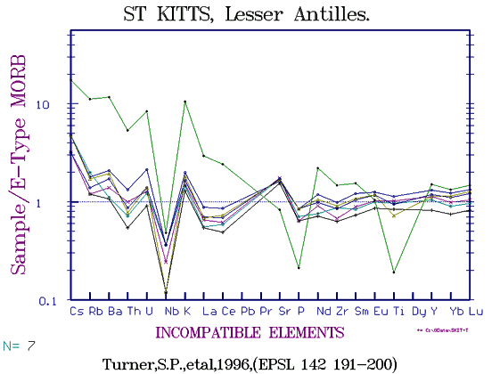
St Kitts is dominated by the recently active Mt Misery volcano at the western end, it's slopes green with sugar cane. A few older eroded rocks extend to the drier east to Salt Pond Point. Dr Peter Baker, then of Leeds made several studies of this island (Baker, P. 1984, J.Geol.Soc.Lond. 141,401-411) and I analysed some trace elements for him at one point. However the data by modern standards is rather erratic and that of Turner, (1996, EPSL 142) is to be preferred. St Kitts is only slightly more potassic that Statia and includes a similar range of rock type, from olivine basalt to occasional rhyolite, but predominant andesite.
Nevis lies only a couple of miles to the SE of St Kitts and consists of a single cone about 3000ft high with an older basement extending to the SE. Hot springs occurred on the island but we could not find them, they had been "lost". We analysed some samples in 1975 at UPR, but these seem to have been mislaid as well. They were mainly andesites of about 58% silica. The crater is still well-formed and not eroded. A point of older basement rocks extend to the SE. Montserrat
Redonda Redonda is a mere rock of depleted basalt rising from the sea. This island has a low flat eastern sector called Grand Terre which belongs to the Limestone Caribbees, and a massive north-south trending range of overlapping volcanoes called BasseTerre. The active volcano near the southern end, (yet another "Soufriere") was in minor eruption in about 1970 and a geologist was killed by a steam blast. To the south are the very depleted 'Morne Caraibes' basalts, but the northern centres trend towards andesite dacite and rhyolite. We do not seem to have any modern ICPMS data for BasseTerre, but it has probably the widest range in composition of any island if we include the rhyolites of "Les Petites Mamelles". Overlapping airfall block and ash give an impression of simultaneous activity along a rift zone In the field we grouped the chain into apparent sectors. Morne Caraibes which includes basaltic pyroclastics in the south, the Souffriere sector, the Pitons Bouillant, the San Touche sector, Morne a Louis and the Northern centres. But, as can be seen from the variation diagram. all form a continous series of common chemistry. (Gunn, Roobol & Smith, 1980, Bull. Vol. 43-2, 2403-2411) Several streams have cut valleys several hundreds of feet deep, so a range in time is included. Samples have been dated from 47 - 777 ma.
Dominica is again about 25 miles long, rising to 1447m in Morne Diablotin. The rocks are mostly basalt-basaltc andesite. We did no work here and while Seismic Institute had some data, again these seem have fallen into the cracks of the hard drive.
As indicated above, we spent about three seasons here. Mont Pelee in the north which erupted so disastrously in 1903 and again in 1933, seems to be of quite constant andesite composition at 60% silica. The flanks are littered with huge blocks of shattered spines flung down the mountainside with great force. The definitive nuee ardente in 1903 swept down the mountainside and over the town of St. Pierre, killing 30,000 inhabitants and sinking ships in the roadstead.
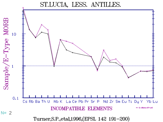
Morne Jacob, an eroded remnant lying to the east a few miles is, as mentioned above relatively enriched in Rb, Ba and light REE (Gunn et al, 1974, Davidson, et al, 1996). There is still only minimal data (about 30 samples) but not only is Rb approx double Y but Ba is about double that of Pelee. Morne Jacob is on the wet side of the island and collecting involves slithering over slimy boulders, but it deserves more attention. At the southern end of the island is an extensive complex of older centres of which a special study was made by Denis Westercamp of BRGM. This island, about 30 miles long, is well known for the two pitons which tower over the southeastern Coast. To the north of them is a hydrothermal area of hot springs, Soufriere
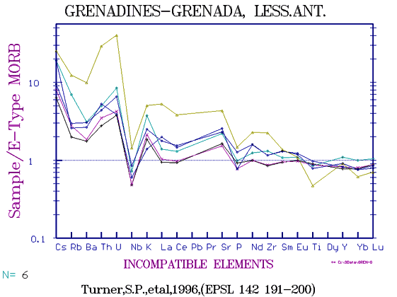
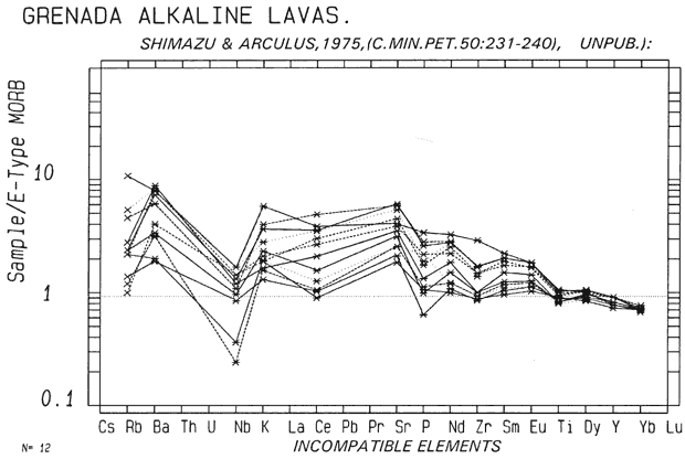
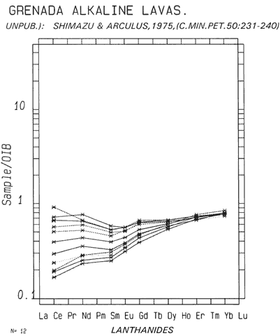
Data from Canouan and Carriacou, (Lewis and Gunn, 1974) show a mixture of Pelean-type andesite with the more alkaline type found in Grenada. This unusual name comes from the crossed seas and rough water experienced in this sector which has numerous submerged centres. Samples dredged from the active Kick 'em Jenny (Devine & Sigurdsson, 1995, JVGR 65) are olivine basalts to basaltic andesites of an extrapolated K(60) of 1.6. This island aroused a good deal on interest when Richard Arculus discovered high Mg alkaline rocks which became to be called basanitoids. They are however of quite calc-alkaline fingerprint but the REE especially show a progressive change towards a more alkaline rock. This seems to be seen in most regions in the late stages of volcanism, the Volcan Xitle flow in Mexico City for example is the same type. The Nb anomaly disappears, but the low Ti, Ni and other characteristics of orogenic basalts remain.
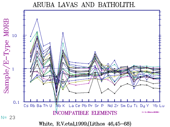
Some maps show the coastal islands off the coast of Venezuela as part of the lesser Antilles. Again, islands closer in shore are of uplifted limestone mainly, (Isla Margarita, Isla Tortuga) while Bonaire, Curacao and Aruba include lavas and some quite fresh diorites and other intrusives. Except for the higher Ba, the fingerprint is typical young island arc.
Conclusions: Arc rocks seldom show the well defined trace element trends seen in oceanic basalts and OIBs. It is possible that the ME are the result of the partial melting at a range of temperatures of Oceanic crust. There seldom if ever seems to be a sedimentary component, perhaps this is all scraped off during subduction. Large amounts of water must be added by chloritisation of oceanic crust. Arc volcanies, as well as emitting enormous amounts of steam and hence being highly explosive, also contain large amounts of CO2. This COULD come from globigerina ooze trapped between pillows, but there seems to be no CaO enrichment. Some sea-floor sediments are K-enriched illites, some are siliceous diamtomaceous rocks, but erratic high K or silica is not seen. Again it MAY be that partial melting takes in whatever trace elements may be present, the range does not exceed that of NMORB - EMORB. Subducted AOB islands COULD explain the erratic appearance of alkaline rocks such as seen in Grenada but these ae usually only seen in the older centres. One definite fact has emerged, there is a remarkable similarity in range of composition in all arcs world wide, though the LILE are on averaged more concentrated in the mature continental arc sectors. We cannot claim yet that we thoroughly understand the arc rocks. Copyright © 1998-2006 Dr B.M.Gunn |