 Orogenic Andesites Orogenic Andesites
(Part III)
Alaskan, Aleutians, Kamchatka, Kuriles, Japanese, Mariana and Philippine Arcs, Indonesia, Solomons-New Hebrides, Tonga Kermadec, New Zealand Arcs.
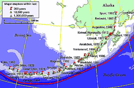
Aleutian – Alaskan Arc
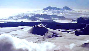
The Aleutian Arc abuts the Alaskan mainland behind a deep fiord penetrating the coast to the city of Anchorage. The arc is about 3200km long with approximately 100 volcanoes of which 40 are active giving rise to 170 eruptions in the last 100 years. Flying into Anchorage from Japan one passes one massive snow-covered volcano (to 2800m) after another, some at least emitting steam.
The fore-arc trench is up to 7000m deep, which, while less than the 10,000m of the Tonga Trench, is still a major geographic feature.
This poses a question. Why an arc? The old solution was that a flat shear plane intersects a globe along an arc sector, but a subducting section of oceanic crust is not a flat plate, it has the same curvature as the sector being underthrust? So an arc should follow a great circle. Something to ponder on.
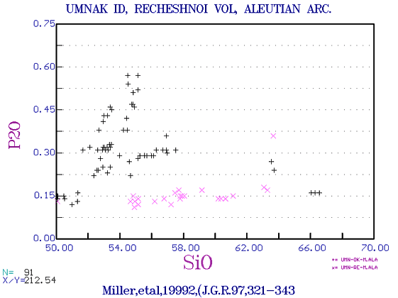
Again we see some tendency for islands away from the continent and closest to Asia to be the least potassic, eg Piip seamount. The variation diagrams below illustrates what now seems to be the invariable wide range of K2O seen in a mature arc.
Alaskan and Aleutian Arc Examples:
 |
EMORB-normalised elements, Double Glacier, Eastern Aleutian arc. Reed, Lanphere & Miller, B.Vol. 54, 631-637)
Note: the Pb, Pr and Yb have been interpolated, (EXCEL does not like blank fields!) |
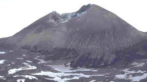
Akutan Volcano
|
|
|
|
Mt Drum, Wrangell Mts, Alaska, (Richter et al, 1994, B.Vol.55, 29-46).
Note that as above the Pb, Pr and Yb are interpolated. Pb should probably show the usual positive anomaly. |
|
|
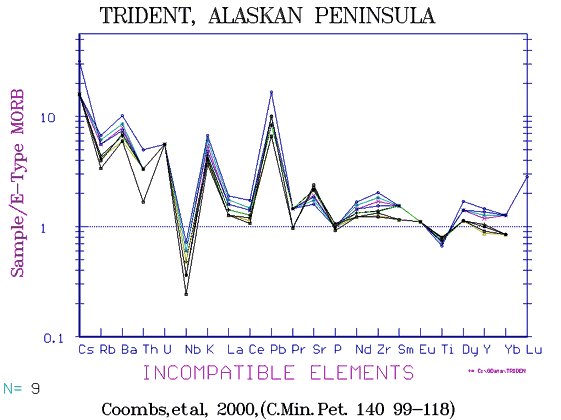
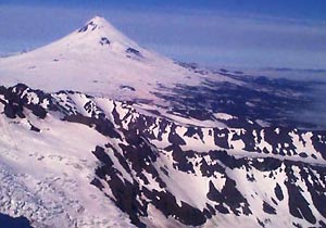
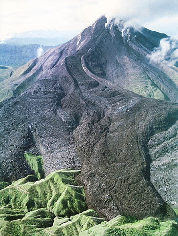
Trident. This volcano on the Alaskan Peninsula has erupted more than once since 1950.
(Coombs et al, 2000) |
 |
Variation diagram for all Aleutian
Arc andesite series. A few alkali basalts are present labelled
"teschenites" and distinguished by their high soda.
(N = ??) Data from GEOROC compilation. |
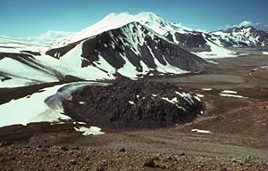
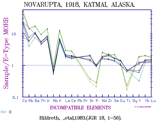
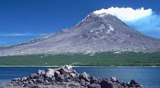
Novarupta of the Aleutian Arc
Photo: USGS
|
The small plug in the foreground marks the site of the vent which (in 1918) poured out the biggest hot ashflow of historic time and filled the whole valley.
Steam from trapped water rose for many years, hence the name "Valley of 10,000 Smokes"
The plug has a rhyolite core with a dacite rim as seen in the diagram below.
|
Okmok with snow blowing off the cindercone inside the large caldera. Photo: USGS
|
|
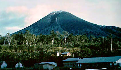
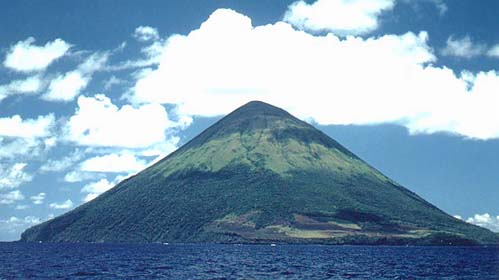
Shishaldin Aleutian Arc
Photo: USGS
|
|
Mt Redoubt of the Aleutian Arc
Photo: USGS
|
|
Augustin Aleutian Arc
Photo: USGS
|
|
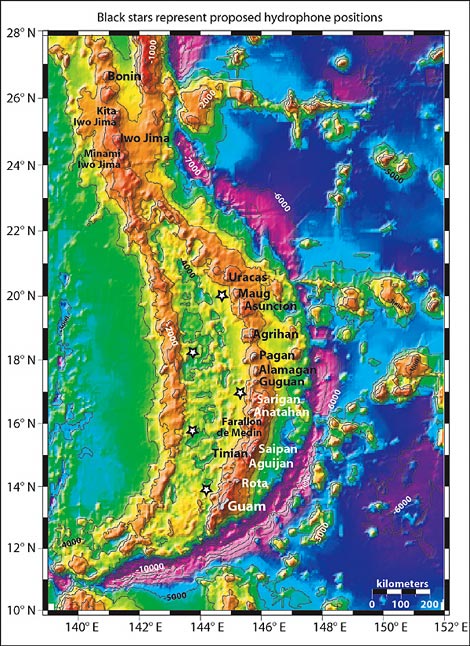
Kamchatka Peninsula
 |
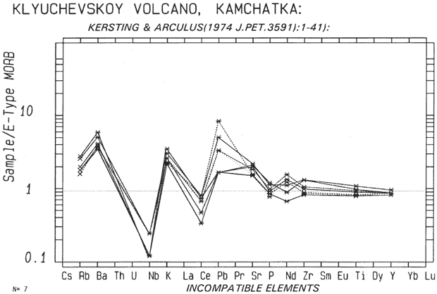
Klyuchevskoy Volcano in Kamchatka. |
 |
The Kamchatka Arc, eastern Siberia. Again a few alkali basalts are included.
Data from GEOROC compilation. |
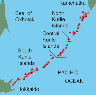
Kurile Arc
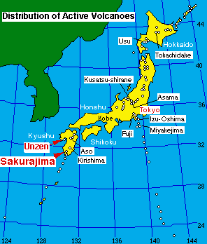
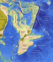
The Kurile Arc extends to the southwest from the Kamchatka peninsula, along the Kurile Islands to cross the island of Hokkaido, Japan, terminating at Aso Volcano (see map below.)
South of this, the Honshu Arc extends to the mid-point of Honshu Island.
There is a great deal of Russian major element data available but not a great deal of new trace element data is to hand as yet.
|
|
 |
Variation diagram for the Kurile Arc, all
data. Islands included are Kunashir, Simushir, Paramushir,
Onekotan, Shikotan, Iturup, Alaid etc, and Kokkaido in northern
Japan. There is little trace data except for the latter.
The Horoman Peridotites are excluded. Some alkali basalts,
eg from Rishiri Island are included. |
|
| Honshu Arc, Japan
This is one of the best documented of all arcs, but the latest GEOROC compilation includes all rocks ever analysed from Japan, a factor of which the practical geochemist must be beware. From a total of nearly 4000 analysed rocks we have to remove 890 with no ME. As we have seen from elswhere, the rock names applied cannot be relied upon, of some 8000 analysed rocks called "Andesite" world wide, the silica range was found to be from 33% to 80%, so the name had been applied rather liberally. So If we wish to show what the compositions of a particular arc are, and a composite file contains rocks named "Trachyte", "Alkali Basalts", "Sandstones". "Quartzites" "Pelagic clays" etc, we have to reject quite firmly. The many obviously misnamed samples does not help greatly! (as is also seen throughout world literature)
Many rocks named "Olivine basalt" were rejected on the basis of high TiO2 and soda, but as Nb,Zr were often lacking and we know that quite alkaline basic rocks showing the typical calc-alkaline negative Nb-Ta anomaly may be assocated with normal andesite series, some rocks were rejected that perhaps should not have been.
To assemble a file of only rocks of definite orogenic andesite would require a great deal more data, and an intimate knowledge of the geology, a fact which applies to most if not all arcs especially. In some case rocks of high TiO2 labelled "Calc-alkaline basalt" have been left in. Rocks named "not given" were rejected, and some 2600 samples remained. A good many granites and other plutonics remain, though the compositions for plutonites is often erratic. Most of the high K samples shown are granites rather than rhyolites.
|
|
|
|
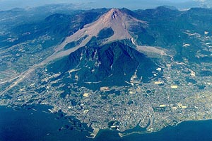
Volcano Sakurajima
|
|
|
Volcano Unzen, Kyushu
|
|
 |
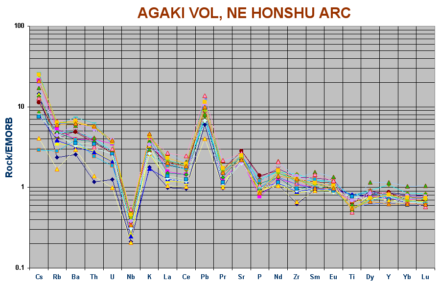
Akagai Volcano, NE Honshu Arc. |
|
|
Variation Diagram for all Honshu Arc rocks. |
|
|
Towada Volcano. Hunter & Blake, J.Pet. 36, 1579-1604)
Though no REE, this shows a moderate active arc profile with a K(60) of only 0.75, something one expects to see in barely emergent islands. |
|
|
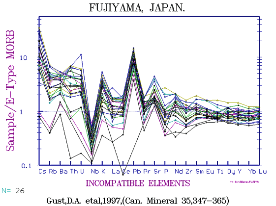
Fujiyama. Fuji is mainly basaltic andesite. The fingerprint is slightly messy with some signs of alteration. One or two values are obvious errors, but as the data was taken from the GeoRoc file it has passed through many hands. One might expect a similar composition to the central volcanoes of New Zealand. both being mature arcs, but Fuji is less potassic with a projected K(60) of 1.75 vs 2.0.
Data from Gust et al (1997, Can. Mineral. 35: 347-365.)
Note that the more basic samples appear to be proto-arc. Fuji is so unmodified one would expect only Recent sample to be obtainable. |
| Ryukuyu Arc |
 |
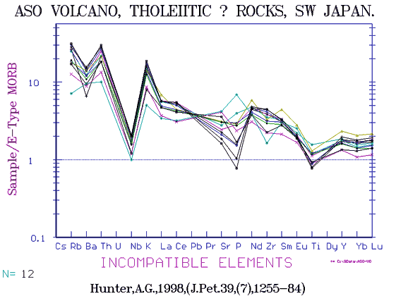
Aso Volcano, Kyushu Japan. Hunter, A.G., 1998 (J.Pet. 39, (7), 1255-84) Aso is suprisingly potassic with a K(6) of ~ 3. (see map above) |
| [to come] |
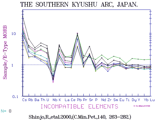
Northern Ryukuyu Arc. Shinjo, R. et al, 2000, (C.Min.Pet 140) |
| [to come] |
Ternary diagram (Na-Mg-K) of Japanese andesites. |
 |
The Ryukyu Arc extending from Northern Kyushu Island of Japan down through a chain or Arc islands towards Taiwan. Notice the REE for the Ryukyu Arc show a spread in values for the higher levels of light REE as does the K2O levels as seen in the variation diagram above. |
Kyushu sector of the Ryukuyu Arc
This extends across the southern island of Kyushu and becomes a chain of arc islands extended in towards Taiwan.
 |
Volcanoes of the Island of Kyushu and the southern end of Japan and of the Kyushu Arc. It includes Kirishima, Sakurajima and other nearby centres. An Early Arc type. At 50% silica the K2O is only 0.5%, no andesites are present.
The northern islands of the Ryukuyu Arc immediately to the south are somewhat more basaltic and LILE depleted. |
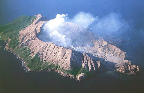
The Izu - Bonin - Marianas Arc (IBM)
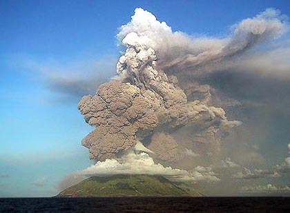
Anatahan erupting, Marianas Arc, 2004.
|
This extends almost due south from central Japan. Pearce et al (1999) have separated examples from the seafloor, Proto-Arc, Early Arc, and the Active Arc. We do not as yet have better locations than this though they have been asked for.
|
|
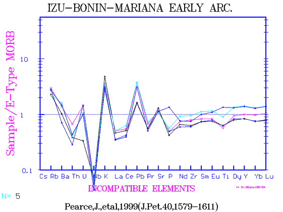
Izu Bonin Arc variation diagram.
This extends south of the Izu Peninsula in Japan towards the Mariana Islands. Because of unusual rocks being found there, it has been subject to a good deal of research.
Note the wide spread in all elements especially Fe and Al, due to progressive change from Proto arc - Early Arc - Active Arc types with increase in K, Rb, Ba, Th, U, Cs, and decreasing Fe. Even higher K "Trachy-andesites" are found on Iwo Jima and some odd "Liparites" with 10-12% K2O on Chichi Jima. The even odder high Mg, low SiO2 very depleted "Boninites" occur here but rarely anywhere else. Extreme ferro-basalts are also found. |
 |
When the bulk of the components are below 0.5 EMORB, Peate et al call thse "Proto-Arc" andesites, the most primitive of all. |
 |
With most elements of most samples lying between EMORB and NMORB, these rocks are proto-arc. |
 |
The data also includes that from several drill holes (see refs below) and is very mixed. Here we see a few very high TiO2 alkali basalts, a range of arc types, some ordinary tholeiitic ORB's and the unusul very low Ti magnesian bonnites . |
 |
For V, the IB arc rocks merge almost completely. The highest V (7-800 ppm) rocks are extreme ferro-basalts with 24 - 28% FeOT, but of unknown affiliations ( They are simply labelled "basaltic andesites"). As always they peak at the Ti-mt point. suggesting extreme fractionation in at least some rocks (presumably IAB's) There are too many partial analyses and not enough ICPMS TE data to separate so many rock series at this point, (Dec 2004) |
Click for Refs
References for the IB Arc are from GEOROC, Dec 2004,
|
| Marianas Arc |
|
|
The Marianas Arc.
While with fewer rhyolites the Marianas rocks are as varied as those of Izu Bonin. Partly this is due to the inclusion of drilled fore-arc and back arc rocks, which is surprisingly varied.
Iron shows a distinct peak at 6% MgO, typical of Early Arc and Proto Arc rocks, and some boninites are also present. We assume the low alumina rocks are those of proto-arcs closest to MORBs in composition. Higher alumina belong to the mature arc samples |
|
|
IBM Proto-Arc (Pearce, J. et al, 1999 (J.Pet. 40, 1579-1611))
Note similarity to primitive IAB's of the Tonga Kermadec and Vanuatu Arcs, see below. |
 |
Fingerprint for islands of the Mariana Arc.
With Rb, Ba, Pb etc well above average ORB, these are typical active arc. |
|
|
IBM Early Arc.
Again a match may be found with L'Esperance Rock in Tonga-Kermadec, see below.
(This group of 5 diagrams date from about 1998 - 2000) |
|
|
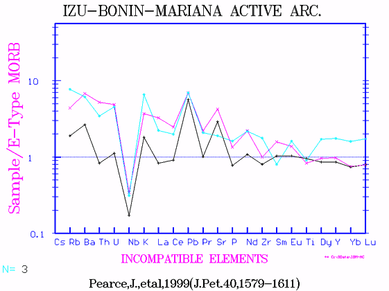
IBM Active arc; presumably islands. |
|
|
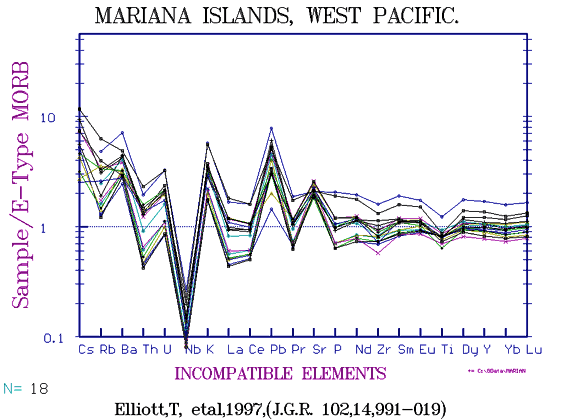
Islands of the Marianas Arc, western Pacific.
|
|
|
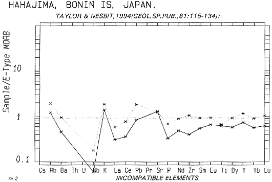
Hahajima in the Bonin Is South of Japan is a long way from the Asian mainland and very depleted in LILE. |
|
|
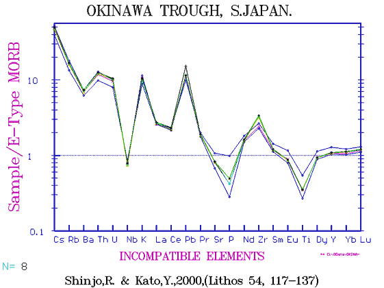
The Okinawa Trough is a back arc basin SW of Japan. These examples appear to be very potassic for such a location, however the China sea is compatitively shallow. |
This excellent bathymetry depth chart courtesy of the NOAA
Philippine Arc
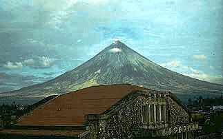 Mayon volcano
|
The Philippine Islands are largely of volcanic origin and extend
from the island of Luzon in the north (about 400 miles in length)
to Mindanao 600 miles to the SE, of slightly smaller size. Between
are a score of smaller islands. A dozen volcanoes are active
including the graceful Mayon (2462m)
at the extreme south-east of the Luzon Peninsula, near San Bernadino
Strait. With 47 eruptions since 1616, Mayon still retains its
regular shape in spite of nuees ardentes and a generally explosive
nature.
Mt Pinatubo, well known for it's massive
eruption in 1991 which left ash at least 2 in deep over 4000
sq km is located less than a hundred miles NNW of Manila. About
50 km SSE of Manila is Taal volcano which has a vent on an island
located in a caldera lake. Taal is variously reported to have
erupted 33, 34 and 41 times since 1572.
|
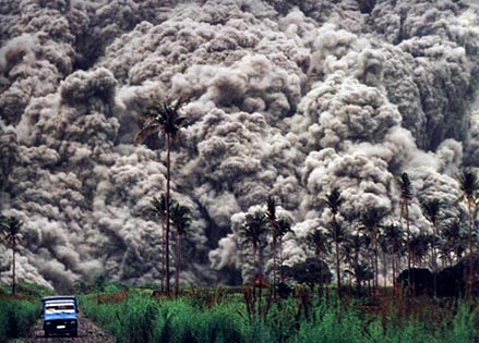 A nuee ardente during the recent Pinatubo eruption (see result below)
|
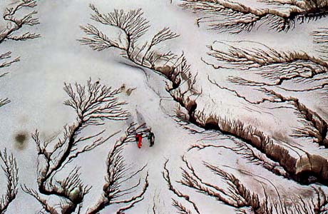 Pinatubo, rain-etched ash after the 1991 eruption in the Philippines.
|
Two cubic miles (9km3) of material was erupted from Pinatubo.
 |
Variation diagram for Mt Pinatubo. Data for Pinatubo is erratic, no Nb or Pb is included and there are so many omissions that meaningful normalised diagrams cannot be constructed. |
|
|
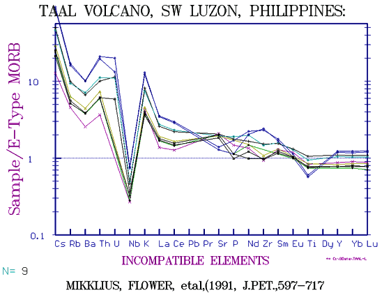
Taal Volcano fingerprint Philippine Islands (south of Manilla).
(Nb calculated from Ta x 15) |
 |
The Luzon Arc, normalised to EMORB diagram. |
 |
The Luzon Arc, Philippine Islands. Actually slightly more elevated in K(60) than Japan, with ~1.75% average. A handful of alkaline basalts are included. This arc includes such well-known centres as Mayon
and Pinatubo. |
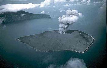
Krakatoa (Krakatau)
Photo: Bob Decker
|
East-Indies Arc There are more than 130 volcanoes in the East Indian (or, Sunda) arc including highly potassic centres such as Muriah and Tambora. The greatest explosions ever recorded on earth are those of Tambora on Sumbawa Id, (1815), when 36 to 43 cubic miles of rock and ash was discharged, much of it from the cone itself (with 40,000+ deaths mainly from famine); and of Krakatau, on an island in the strait between Sumatra and Java which erupted in 1883 and threw pumice 33 miles high, while dust fell 3313 miles away 10 days later. 36,380 people were killed either by the ash fall or by the resulting tidal wave.
|
Toba in Sumatra has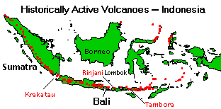 the world's largest caldera at 680 sq miles, and the "Guiness Book of Records" gives the ejected volume as 480 cubic miles (2000km3) at 75000 yr BP. the world's largest caldera at 680 sq miles, and the "Guiness Book of Records" gives the ejected volume as 480 cubic miles (2000km3) at 75000 yr BP.
Krakatau has a K(60) of ~2, being much less potassic than Tambora. No trace elements available for Krakatau. Other destructive volcanoes include Merapi in Java and Kelut, notorious for its mudflows until the crater lake was drained. |
 |
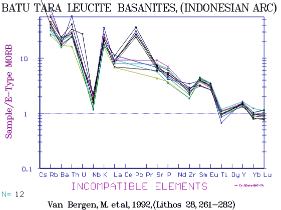
Variation diagrams for Sunda (Indonesian) Arc. This has a very wide range of composition with several highly potassic, often leucitic, centres which lie on the northern continental edge of the arc, facing or in, the Indonesian Sea. These include Muriah, which forms a peninsula on the northern shore of Java; Tambora on the northern side of Sumbawa, and Batu Tara, an island off the northern shore of eastern Flores. |
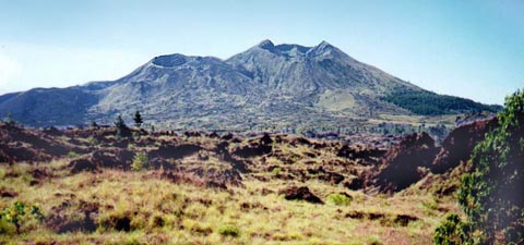
Batur I, II, III from right, (on Bali, 1996). Adventitious cones inside caldera with caldera lake below right.
1917 flow in foreground, 1973 flow from Batur IV in left distance.
Gunung Agung (10,300ft) is the dominant volcano in eastern Bali. It began its last eruption 18-Feb-1963, and on 17-Mar-1963 the top 300ft was blown off. Between one and two thousand people died and much of the agricultural land at the foot of the volcano was destroyed.
No data available.
|
 |
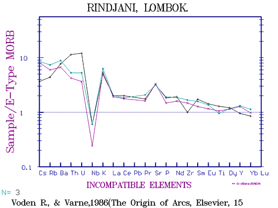
Though it is a massive 9000ft active cone on the island of Lombok, east of Bali, Rindjani is typical island arc in composition.
Rindjani dominates the northern half of the whole island. |
Tambora, Sumbawa Id.
With 6% K2O at 56% SiO2, Tambora projects towards a K(60) of 8, i.e similar to Vesuvius. Pre-1816 Tambora has a K(60) of approx 6. However, nearby volcanoes such as Rinjani of the Island of Lombok (from very few data) have a K(60) of about 2.5.
|
|
Tambora, Sumbawa Id. |
|
|
Muriah, a shoshonitic andesite of Java. |
 |
Batu Tara, (Flores) |
In spite of the lavas being termed "Nepheline Trachybasalt" in the case of Tambora and "Leucite Basanite" or "Leucite - biotite Basanite" for Muriah and Batu Tara, all retain the typical continental andesitic fingerprint. They are similar to the ultra potassic leucite "andesites" of the Roman province, though not sited along an axis of continental collision, but more in a "back arc" situation.
 |
SiO2/K2O diagram for all Sunda (Indonesian) Arc rocks. The leucitic Muriah and Batu Tara especially are easily distinguished from the calc-alkaline arc where the K(60) ranges from 1 - 4% |
New Britain
This island has a chain of volcanoes extending east of New Guinea, culminating in the active caldera at Rabaul with active parasitic cones.
Uluwan, one of the centres in the New Britain Arc.
|
|
|
New Britain, Proto-arc with trench to the north, east of Papua New Guinea. |
 |
Variation diagram for New Britain showing there is actually a wide range from proto-arc to active arc compositions. |
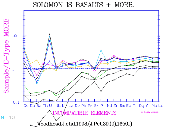
Solomon Islands
The Solomon Island lie a thousand mile NE of Queensland and form a double chain of islands extending from Bouganville in the NW, near New Britain, down to San Cristobal 800 miles to the SE. Altogether there are 990 islands, many are mere atolls, but the total area is reported as being 28,000 sq miles. A little over 200 miles to the north is the atoll of Ontong Java resting on a large submarine lava plateau which has been focus of several investigations. The edge of this submarine plateau appears to surface on Malaita and Sta Isabel. These rocks are tholeiitic basalts of NMORB to EMORB compositions and rather altered, (Tejaba, M1996, J.Pet.37) though the same author produced better data of NMORB’s later, (Tejaba et al, 2002, J.Pet.43.
Large andesitic volcanoes are found on Bouganville especially, (site of the controversial Bouganville Copper mine) but no detailed study seems to have been done on any single centre. Rocks range from andesites, diorites, granites, lherzolites (Malaita), alkali basalts and picrites.
The main islands of Choiseul and Sta Isabel to the NE and the New Georgia Group to the SW enclose the famous "Slot" leading to Guadalcanal and "Iron Bottom Sound", soaked in more desperate history than perhaps any other area of the Pacific.
We have not yet found any summary of the geology of this group, nor visited. Any contributions from readers would be welcome.
Recent andesitic lava flows on NW flank of Bagana
volcano, Bougainville Is, P.N.G. 26-April-1988
|
 |
Solomon Islands.
MgO vs oxides. |
New Hebridean (Vanuatu) Arcs
|
|
New Hebrides Arc.
The literature on the New Hebs has many reference to "ankaramites" and "picrites" Here we see the trends above 10% MgO pointing directly towards olivine with 10% FeOT. |
|
|
Tanna, Island in New Hebrides, west Pacific. The New Hebrides form a "Y"-shaped arc with trenches both to west and east . Another oddity is the long distance the arc lies from the Australian continent. Ambrym (Robin et al, 1993) is similar to Tanna in composition. W.Epi, (Bardsell & Berry, 1910, J.Pet 31) includes "ankaramites", which are quite depleted. |
|
|
Solomon Islands. These were dredged off shore and appear to N-type and E-type MORB, possibly Back-Arc but not recognisably of arc connections. |
|
|
Merelava. a proto arc example from the Vanuatu arc.
Merelava is intermediate in type between Proto-arc and Early-arc.
|
|
|
Aneitum and Tanna, the two southernmost islands of Vanuatu.
EMORB diagram |
 |
Fingerprint diagram for Ambrym, New Hebrides, (Picard, 1994) The data is good though rather old and with many omissions. Th,U have been "guesstimated" from more recent work, as has Pb and adjoining elements. Samples range from magnesian ankaramite to basalt.
|
The North Fiji or Pandora Basin
West of Fiji between it and the New Hebrides (Vanuatu) is a large triangular basin about 450 miles deep. It is bounded to the north by a chain of volcanic island south of the Gilbert Ellice group including Wallis Island, Rotuma (a basaltic island of proto-arc type of about 34 sq km), and the Pandora Bank. [HMS Pandora, which captured some of the Bounty mutineers, was wrecked on the Barrier reef, off Queensland however, not here.]
To the SE lies the Hunter Ridge extending to the island of Kandavu, in which all rocks are calc-alkaline, through the Hunter and Mathew Islets to Aneitum and Tanna in southern New Hebrides Group.
Though deep, 300-4000m, extensive work, mainly by dredging has been done.
 |
Variation diagram of the Pandora Basin.
As can be seen, these are all MORBs, ranging from fairly depleted to enriched EMORB. |
| [___] |
Fingerprint of the Pandora Basin. Though the data is somewhat erratic it can be seen the a wide range of MORB is present, but no proto-arc rocks as seen in the Lau Back-arc basin.
A ridge runs NNE-SSW through the basin and a median trench is reported. Seemingly this is a "Back-arc spreading centre", and from the composition of the rocks, a slow moving one. |
Fiji
The larges island of Viti Levu is about 90 miles across .Fiji consists of two large and about a hundred small islands built almost entirely of orogenic andesite. The islands form a curious left-handed spiral pattern with chains of islands radiating like a left-handed galaxy. Thus the Yasawa and Mananutha Groups radiate west and north, the Lau groups east and south and the Kandavu-Kandavu trench south and west. The location of Fiji close to a right angled bend in the arc pattern for the western-southern Pacific may be subject the group to a rotational shear.
The lavas are reputed to be 10ma to 1ma in age but there are some younger alkali basalts. Some of the smaller islands retain a crater outline, eg Makongai in the Koro Sea has a harbour, Delice Bay, in an eroded crater and may be younger than 1ma. Basalts at Delice Bay have coarse 1cm clinopyroxenes and may be similar to the "Ankaramites" of W. Epi in Vanuatu.
 |
Variation diagram for the Fiji and Lau Groups. The bulk of the rocks have a K(6) of near 1.75% but in the Tavua and Onoilau regions are very potassic rocks called shoshonites - absorokites with Rb often 100+ and with Ba, Sr in excess of 1000 ppm. Zr/Nb is very variable, 10-30, while La/Sm is even more so, 2-100! |
| [To come] |
Wharton et al (1994) show a low-K series from Viti Levu with an E-MORB abundance of REE. |
| [To come] |
Gill & Whelan (1989) demonstrate a high K or "Shoshonitic" series of rather variable composition. |
Students and staff of the University of Tasmania have carried out a series of detailed studies especially on the Kandavu Trench ODP cores. The range from low-K IAB to high K series is remarkable.
Fijian rocks are often somewhat altered and silicified and gold mines operate on the two larger islands.
Lau Ridge
 |
Diverging due north from the Kermadecs is the Lau Ridge which links to the Lau Group Islands and eastern Fiji. A series of seamounts make up the greater part of the southern half of the chain with a few coral-capped emerged shoals such as Minerva Reef. The northern Lau islands are deeply erroded, but some retain a volcanic appearance. |
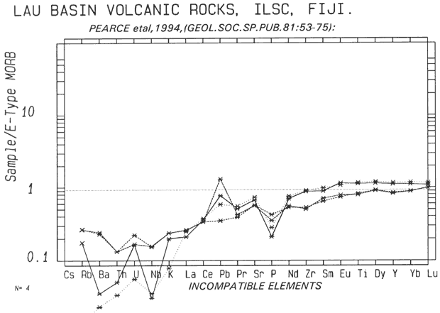
Pearce et al (1994) show very depleted tholeiites from the Lau Basin (between the Lau Ridge and the Tongan Arc), slightly less depleted Lau Basin seamounts with both showing a -ve Nb anomaly. More normal rocks are found on the Lau Ridge itself, (Gill,1976, Cole et al,1990) with an average of 3 - 5 x EMORB compositions. The Niuafo'u basalts ( an island in the Lau Basin) are close to EMORB, (Reay et al,1974) but Nb data are not included.
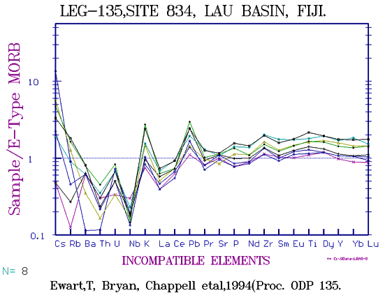
Lau Basin
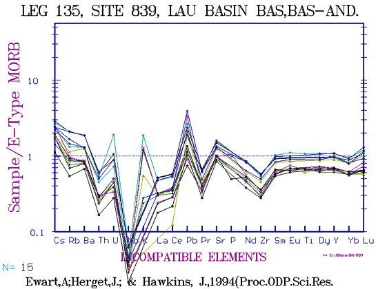
This is a depression between the Tonga Kermadec Arc, and the arc formed by the Lau Islands east of Fiji. As an apparent "Back Arc Basin" it has received considerable attention. The diagrams below show the Lau basin rocks to be rather similar to Proto-Arc, but with more elevated HFSE. Data from Pearce et al (1995) and Boesplu (1990) are similar.
 |
ODP Leg 135, Site 834, Lau Basin |
 |
ODP Leg 135, Site 839, Lau Basin |
Tonga-Kermadec Arc
The Tonga-Kermadec "arc" is actually the only one which is quite linear, extending for 2000 miles from near the alkali-basalt islands of Samoa to fade out in the central North Island of New Zealand. The TK arc is however usually thought of as terminating at the southern Kermadec Island group, though the Tongan Trench (and the volcanic activity) continues southward. The trench which lies to the east is up to 32,000ft or 10,000m deep perhaps surprising in so young an arc. The volcanic islands lie in a chain, often non-emergent, as they may build a cone a few hundred feet above sea-level but if of block and ash it may be quickly knocked down to -60ft or so by wave action as is seen in Metis Shoal, or the new centre at Hunga Haapai or at Minerva Reef.. As in the Lesser Antilles a chain of uplifted flat limestone islands separate the trench from the volcanic chain but whether these lie on a crustal bulge or on older volcanics is not, I believe, known.
 |
Variation diagram for the Tongan Arc between Tafahi near Samoa, and Ata, 120NM south of Tongatabu. In spite of varied fingerprints the different islands show a common variation diagram except for some difference in K2O. Note the typical Early Arc higher levels of Fe & CaO and the tendency of the Fe to peak at 4-5% MgO. |
Recent data (Ewart, Collerson et al, 1998, J.Pet.39) is of high quality and along with the similar data on the South Sandwich Group (Pearce et al, 1995, J.Pet.31) we can at last define element abundances in primitive arc rocks with some confidence. Samples used by Ewart & Collerson et al are mainly the same as those of Brothers, Ewart & Matteen,1977) and the P and K values are from the old data. The P can be seen to be erratic and should be ignored until new P data are available. Using the numbering system used by Ewart, Collerson et al, beginning from the north and working south, the main volcanic centres of the Tong-Kermadec Arc are:
 |
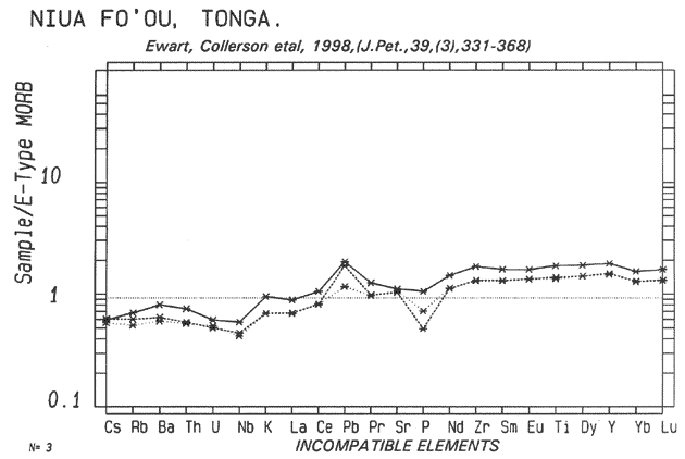
Niua fo'ou. This lies west of Samoa and has an almost N-MORB fingerprint as was pointed out by Ewart, 19..) The adjacent Lau Basin rocks are similar, though sometimes showing an incipient Nb anomaly and slight increase in K-group elements, (Pearce et al,1994). |
 |
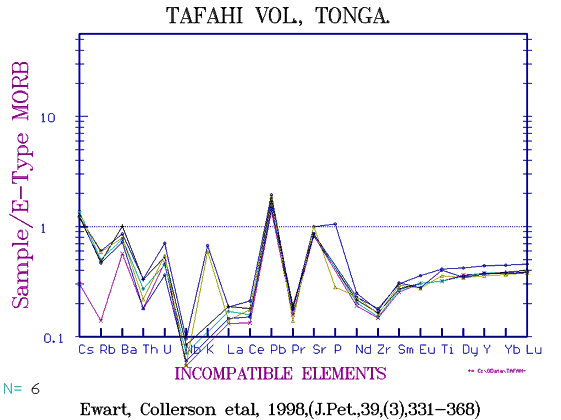
Tafahi. IAB's with unusually low HFSE at 0.3 - 0.5 of E-MORB levels, but with a distinct Nb anomaly.
Tafahi, is an extremely depleted IAB from the northern Tongan Arc. |
 |
Niuatopotapu. IAB's with similar low HFSE but more elevated LILE and recognisably of arc origin and calc-alkaline affinity. |
|
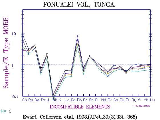
Fonualei. Slightly more enriched basaltic andesite-andesite but still with only Cs, Rb, Ba, U, K? and Pb in excess of E-MORB. The regular spacing between primitive and more enriched samples might suggest olivine fractionation, but correlations with MgO are poor in general.
Fonualei, is 20 miles south of Tafahi, a sklightly more enriched IAB. |
 |
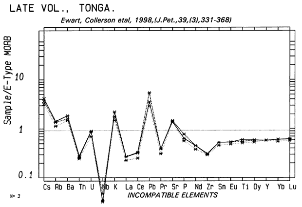
Late. A gently sloping black cone lying WSW of Vavau, much less steep than nearby Kao, shows IAB's of exactly the same fingerprint but more depleted in all elements. |
|
Metis Shoal. Reduced to below sea-level after an eruption in the 1960-'s, is termed a dacite but has the same depleted HFSE as Late with Rb and Cs at x6 and x10 E-MORB. |
 |
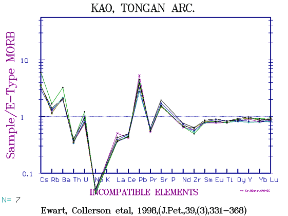
Kao. A symetrical steep cone (see pic), has 50% more HFSE but similar LILE to Late, an unusual difference between centres. It is more common to see similar HFSE and differing LILE. |
Kao, a recent cone in the Tongan Arc, west of Nomuka.
Out of view to the side is Tofua, a larger low island and caldera with a fumarolic vent.
Photo: B.Gunn
|
| [___] |
Tofua a few miles to the south is a larger island but has had 2/3 of the cone blown away leaving a large collapse caldera and lake. A small sulphurous vent is found near the caldera fracture. From one sample the composition is similar to Kao. |
 |
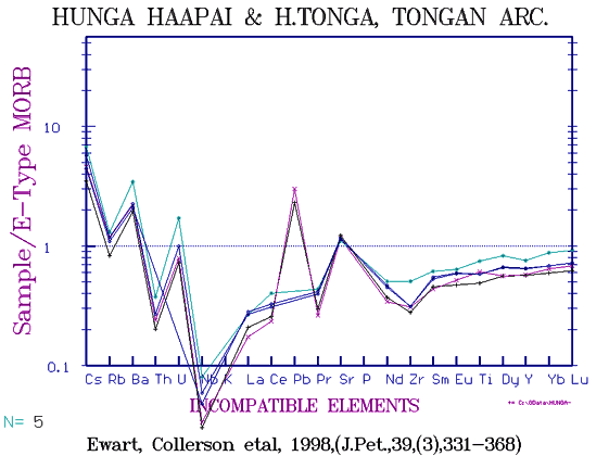
Hunga Ha'apai. Two remnants of a crater rim are built of basaltic flows and a mile to the south is the new cone of Hunga Tonga which a few years ago rose 200ft above sea-level but is now -60-ft. A 10ft dike remains standing across the crater and causes a wave break. Composition is identical to Late. |
| [___] |
Eua Island, near Nukualofa, is a high island with no recent volcanics but does include exposures of spilite. |
 |
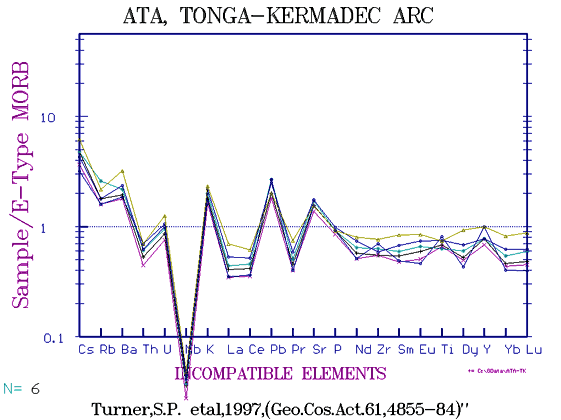
Ata is an isolated uninhabited island standing about 1000ft above the sea, a day's sail SW of Nukualofa, Tonga, with a largish patch of life-sustaining coconut in the remnants of the crater.
(A few months ago a crewman gave a GPS position of 4 miles off on a dark night. Having been there before I said, squinting at the cliffs against the stars, "Looks more like four hundred yards to me!" and put the wheel hard down! Luckily the water is deep close to! Missed her by a good 200!)
Perhaps being extinct for 100,000yr or more, Ata is the most "primitive" of the southern Tonga Kermadec arc. |
Kermadec Islands
| [___] |
Raoul Id, is the largest of all, having several centres including the submerged Cumberland Bay. There is a wider spread of composition from basalt to dacite, but of the Late-type fingerprint. |
 |
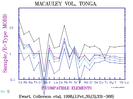
Macauley is an odd island with a base of two flows of basalt and basaltic andesite on which lies an extensive slab of airfall dacite-rhyolite. Though now only a mile or so across it must have been once much bigger and is the largest exposure of rhyolite in any arc.
The rhyolite has consistently more elevated HFSE than Metis Shoal. |
 |
Curtis Id. forms a low crater of brightly colored rock suggesting alteration, and hydrothermal activity is obvious (and pungent). An older outlier lies a mile away. Earlier work (Ewart, Brothers, and Mateen, 1977) showed a wide range of composition from basalt to rhyolite but correlations are poor and no rock has more than 0.6% K2O. However, the new data (on the dacites and rhyolites only) show the curious elevation of HFSE compared to basalts with lower light REE than E-MORB and La/Sm of <1. Deception Id rhyolite has La/Sm of slightly >1 (Smellie, pers.comm.) but those of the South Sandwich group (Pearce et al, 1995) are also <1. |
 |
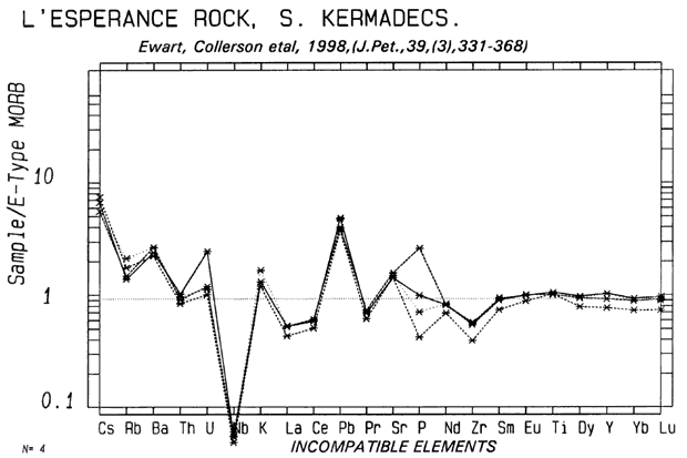
L'Esperance Rock. This is the southern most emergent exposure and is merely an isolated rock. Nevertheless a wide range of composition occur |
The Tonga-Kermadec Arc is rather unusual as it extends from near Samoa for 1500 miles to the Kermadec Islands (and then on to New Zealand).
 |
The 30,000ft-deep Kermadec-Tonga Trench lies to the east.
Sediments from the north near Samoa have a fingerprint very similar to potassic andesites though constituted of illitic clays, xeolites and carbonates. Ewart, Collerson et al 1998, suggest that these sediments become incorporated in the subductive slab and contribute to the composition of arc andesites.
|
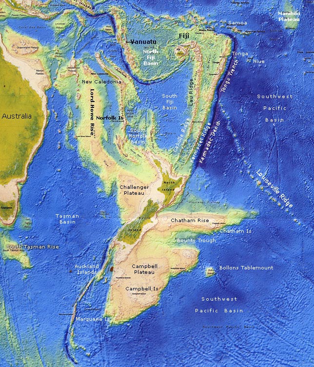
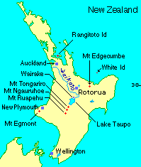
New Zealand
Tectonic map of the South Pacific-New Zealand area modified from a GNS (NZ) production.
|
In contrast to the other circum-pacific arcs which form a discontinuous series of convex-outward andesitic arcs, the sector from the New Britain Arc east and SS west to the Indo-Pacific Rise is more complex. From New Britain, through the Solomons, New Hebrides, the arc volcanic chains have a trench on both side with subduction taking place both to the NNE and to the SSW. A single linear trench extends SSW from Samoa for 1600 nm lying east of the Tonga-Kermadec volcanic islands and fading out near East Cape, New Zealand. The TK arc continues through White Island off the coast of NZ, through Mt Edgecumbe, Mt Tarawera, the Rotorua thermal area and its many collpase calderas, the Okataina Centre, through Rainbow Mtn, the Maroa Centre, Mt Tauhara and theTaupo Centre, the Pihanga Group, the Tongariro Group, Mt Ngauruhoe and finally the 9000ft Mt Ruapehu.
The older Lau Group which lies between FiJi and Samoa, also extends sub-parallel to the TK Arc south through a series of submarine cones including Minerva Reef to the Mayor Island obsidian dome near the coast of New Zealand and may continue through the Pirongia group of extinct volcanoes to Mt Egmont. Extending SSW of NZ is the Maquarie Ridge, a defunct spreading centre now the locus of the major dextral Alpine Fault. To the east and south are the shallow (-1000m) Chatham Rise and the Campbell Plateau of continental rock dotted with alkali basalts islands.
A series of submarine vents named Rumble I, II, III, IV lie along a southern extension of the linear Tonga Kermadec "arc". (Gamble et al, 1993, J.V.G.R. 54, 265-290). They have a composition close to E-type MORB with K, Rb,Ba etc at about x2 - x3 EMORB levels.
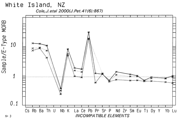
Twenty miles off the coast of New Zealand in the Bay of Plenty, on the same line is White Island, so-called presumably because of the frequent coating of light-coloured ash. The crater rim rises about 1000ft above the sea but the crater is breached on the southern side so the vent is too close to sea-level for comfort. White Id seems to be always in a state of low level activity with a high emission rate of noxious gases, especially SO2, H2S, Cl2 and steam. Fine white ash on calm days falls back near the vent and is so hot that as one wades .through the soft, knee deep ash ones legs get burnt. The gases are suffocating and a respirator must be worn.
A hundred years ago the crater was mined for sulfur and remnants of old concrete buildings, damaged in an eruption, can be seen in the bay. Eventually all the miners died of chlorine gas poisoning. White Id. is looked upon as being a potential Krakatau. Its composition is andesitic, but there is only a small amount of major element data, (eg, Black, 1970, B.Vol. 34(1)), but Cole has recently published a new study with 187 major analyses and a variable number of trace elements (see below). The approx K60 is 2.0. Note the incipient caldera wall collapse line. Forty miles west is Mayor Island, a rhyolite-obsidian dome with a central caldera.
 |
Variation Diagram for White Id, NZ. The K(6) averages about 1.5 and all lie in a silica range of 55 - 65%, the more basic ones appearingto be ankaramites as seen in the New Hebrides. |
 |
White Id. volcano, NZ
Note low Sr and low REE generally compared to relatively high Rb,Ba, Th.
|
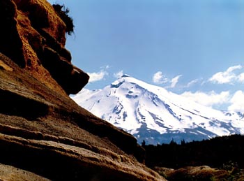
A 3000ft dacite dome; Mt Edgecumbe, lies 10 miles inland and further south lies;
|
Mt Tarawera, a rifted rhyolite dome which erupted basaltic scoria in 1886, covering the surrounding country in several feet of ash.
|
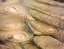 The Rotorua Thermal area lies about 20mi west of the Tarawera dome. Rotorua is one of seven clustered lakes each 1-3 miles across, all collapse calderas after ignimbrite eruptions. Pohutu is the most active remaining geyser at Whakarewarewa, (usually known as Wokker!) and lies amongst dozens of boiling pools, geysers, silica terraces and mud lakes that go "plop" in the night like porridge cooking. If you live there long enough you get used to the smell of rotten eggs. Presumably not too far below the surface a mass of rhyolite magma is slowly forming granite. Extensive drilling for geothermal steam and water for hotels, hot private pools, central heating etc has reduced hot spring activity in recent years.
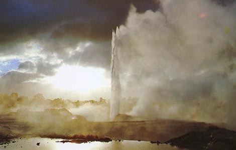
Pohutu Geyser.
|
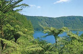
Blue Lake
smallest of the Rotorua rhyolitic calderas. All vegetation here was totally destroyed in the 1886 Tarawera eruption. That shown has grown since. |
 |
 |
m |
At Wairakei and at Broadlands 30-50 mi south are some of the world's largest geothermal electricty generating stations. Water for the steam to drive the turbines has to be heated through a heat exchanger because of the large amounts of dissolved silica and other elements which turbine blades do not like.
Near lake Taupo lies Mt Tauhara dacite dome and then comes the large caldera of Lake Taupo (about 15 miles in average diameter) which G.Walker (the well-known volcanologist) has dubbed "The largest volcano on Earth". Much of the area is buried in sequences of ignimbrite emitted from the Taupo caldera, ranging in thickness up to 100ft or more, and Walker has found Taupo ash shower material in Auckland over 130 miles away. The 130AD erruption from Taupo produced ejecta estimated at 30,000 million tonnes, covering 6200 square miles, 26 times the devastated area of Mt St Helens (1980)
[Guiness Book of Records].
|
 |
Variation diagram for the Taupo Volcanic Zone, New Zealand, between White Id in the Bay of Plenty, and the 9000ft stratovolcano Mt Ruapehu in the centre of the North Island. Mt Egmont in the west is not included.
Note the group of low Al pantellerites from the Mayor Id obsidian dome. One wonders what the Zr content might be, but no data. |
 |
Variation diagram for ~ 100 North Island andesitic suite arc rocks. Those from the Egmont region, Tongariro National Park, Lake Taupo, Maroa, Broadlands, Mangakino, Rotorua lakes, Tarawera, Western Bay of Plenty - Kaimai Ignimbrites, White Id, Mayor Id, Little Barrier, Maungatautari, Pirongia, Karioi, are all included.
The Auckland and South Auckland Volcanic fields which are AOB's are excluded, though included in the GEOROC assemblage. The Northland Kerikeri basalts are left in though of doubtful affiliation as are some of the Tangihua Complex and ophiolites of the far north.
The dense cluster of rhyolite-dacite composition of left are all ignimbrites. These rocks are very deficient in many trace elements. |
 |
The REE for the New Zealand Arc. Note the low maximum of La for the ignimbrites on average compared with, say, the Andes, though a very few are more enriched. |
 |
Metals for the New Zealand Arc. |
 |
Zr vs alkaline earths. |
 |
Th/U has a high ratio of about 4 in the basalts-andesites. |
 |
Silica diagram for TVZ, showing a mean of 1.5 at 60% silica. |
 |
Ignimbrite sheets at Mangakino on the Waikato River north of Lake Taupo. Layer upon layer, often 20 - 50 m thick line the river banks. Because of trace element deficiencies once looked on as worthless country only fit to grow pine trees and scrub, the area now has green and productive farms. (rhyolites retain moisture in times of drought!) |
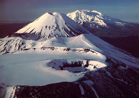
Mt Tongariro (foreground), Ngauruhoe and Mt Ruapehu in early morning sun.
|
 |
Fingerprint for Mt Ruapehu active cone. Unlike a few more symetrical cones such as Mayon and Fuji, Ruapehu is an indescribably ugly heap of rubble with block, ash and lahar interspersed with thick short andesite flows. Having been decapitated with 3-5000ft of it's summit blown off, Ruaphehu is no beauty. It can also have the foulest of weather with 50-70 knot westerlies screaming round it's isolated slopes with snow and sleet that drive through any garment made by man. Data is mainly from Waight etal, 1999, (NZJG&G 42, 513-532) |
 |
The three active centres in Tongariro National Park have surprisingly minimal data with no REE at all for Mt Ngauruhoe the most active centre. From what there is, the compositions appear to be relatively constant, the dominant magma type being orthopyroxene basalts and andesites. Soda is fairly constant at K2O x 2, but in the rhyolite ignimbrites of the area, K can exceed soda. |
 |
Zr vs alkaline earth elements. Though it appears erratic, the Sr is effectively constant as is normally is in andesite series while Ba (along with K, Rb, Th, U) increases with silica. |
| Tongariro is an andesite dome which has blown it's top and developed several parasitic vents with currently only fumorolic activity. Nearby is Mt Ngauruhoe, a symmetrical cone of 7,500ft which has been quiescent for several years.A few miles south is Mt Ruapehu, (9,000ft) which has blown about 5,000 ft from its summit in pre-historic time. It emitted dense ash clouds in 1994.
The black streams below the Ruapehu eruptive cloud are mudflows, not lava flows.>>
Note the sequence of explosions. The atom-bomb type mushroom cloud is mainly steam from the lake, the black columns are lake-bed mud, and the linear white ejecta are new hot magma particles.
|
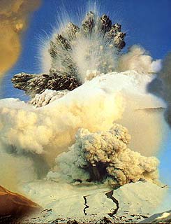
Ruapehu in a recent explosive mood.
|
 |
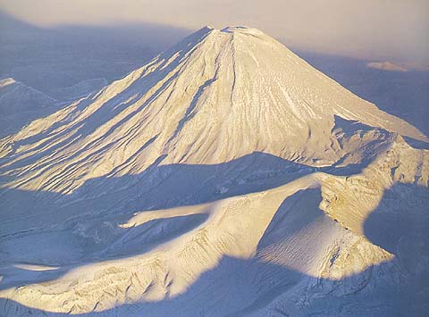
Mt Ruapehu, (9,000 ft), NZ.
This volcano has blown about 5,000ft from the summit, a crater lake lies beyond the peak. In the foreground is layered scoria from past eruptions. Poor material for analysis!
Photo: Dr Diana Gunn
(Pre-1994 eruption)
|
Ngauruhoe is New Zealand's most active volcano erupting every 15-20 years, though the last eruption was 1978. Here here covered in yellowish ash from the 1994 eruption of Ruapehu ten miles distant. The white coating is a light skiff of snow. Ngauruhoe is in fact mainly basaltic andesite.
Photo: Craig Potton
|
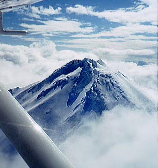
A hundred miles to the west lies Mt Egmont (8,000 ft.) and several erroded older remnants, of much more potassic composition than the Ruapehu group. It is at present dormant.
| Mt Egmont, 8,000ft andesite cone, in winter. No activity in historic time (though one can live in hope!)
Native verbal history has it that Egmont last erupted about 250 years ago.
Photo: B.Gunn
(Note; no automatic pilot. One flies the Cessna 152 with the left hand and takes the pic with the right!)
|
 |
Egmont is mainly basaltic andesite but with K(60) of 3 compared with 1.75 for the andesitic Ruapehu, (Graham & Hackett, 1987, J.Pet.28); while the range for the whole Taupo area is from 1.5-2, (J.Cole, Data File).
 |
Recent data (Price et al, 1999) for Mt Egmont and associated older eruptives, N.Z. |
 |
REE for Mt Egmont, compare with Mt Ruapehu in Tongariro National Park about 150 km to the East. Data from Price et al. |
Copyright © 1998-2006 Dr B.M.Gunn
|